Graded School Ruins Along the Dawkins Trail

Ivyton Graded School – Ivyton, Ky. Author’s collection.

Harold Ickes said that “the new rural schools, made possible by good roads, are quite as
modern as the best city schools. Where it was necessary to have eight one-room schools in the
past, there is now a single eight-room school.” Ickes would know: he served as President Franklin Roosevelt’s Interior Secretary and was responsible for implementing the New Deal. 


Although a number of New Deal programs were involved in building new schools, the Works Progress Administration was the most active. The WPA channeled “more than $162 million through
thousands of state projects and had as many as seventy-two thousand Kentuckians on the 
payroll in the September 1938 peak.”
(Blakey 1986, 59). 


One of those schools is the old Ivyton Graded School which is located just off the Mountain Parkway in Magoffin County. Perhaps you have noticed the ruins on the northern side of the roadway.

The Mountain Parkway (and Dawkins Trail) at Ivyton, Kentucky. Author’s collection.

The ruins first caught my eye when returning from a court hearing in Pikeville in 2013. It was a cold March and spring had not yet begun to bloom, leaving the ruins exposed. I was immediately drawn to the point that I reversed course so that I could explore. 


The Kentucky Heritage Council surveyed the site nine years earlier, in 2004, for its Inventory Survey, observing that

Ivyton School under construction. UK Libraries.

All that remains of the building is the exterior walls. The structure is constructed of  ashlar sandstone blocks laid in broken range work. The school was a one-story, three-bay (w/d/w), side-gabled structure. The centered, arched entry of the façade, constructed with quoins and a keystone, projected slightly from the wall place of the façade. A date stone directly above the entry states: “WPA 1938”. Stone quoins are found on each corner of the structure. None of the windows remain. Each of the window openings has a keystone. The southwest gable end of the structure has three large window openings, a window opening near the apex of the wall and a stone chimney. The school appears to have been constructed in a “T” shape, with a perpendicular gable-roof section projecting from the rear of the structure. 

Date stone at the old Ivyton Graded School – Ivyton, Ky. Author’s collection.

Above is a photograph, taken in 2013, of the date block directly above the entrance to the old graded school. 


I recently returned from another court appearance in Pikeville and made it a point to again visit the ruins. This time, I knew that the Dawkins Trail (Kentucky’s longest rail-trail) crossed the Mountain Parkway at Ivyton. So I explored further on foot. Within a short walk from what has become a de facto trailhead at Ivyton are two of the most unique locations along the 18-miles of open trail, including a 662-foot tunnel and the bridge trussle over the Mountain Parkway. 


So next time you are traveling the Mountain Parkway, be sure to see if you can spot the old Ivyton Graded School!

The afternoon sunlight hits the Ivyton School ruins in November 2015. Author’s collection


Another Nicholasville House is Gone

404 West Maple Street – Nicholasville, Ky. Jessamine County PVA

A month or so ago, my family was walking along Nicholasville’s West Maple Street when my wife commented on what appeared to be work being done at 404 West Maple Street. My heart jumped as I thought that this circa 1921 residence would be remodeled and given a new lease on life.

This, however, was not to be. On Black Friday (2015), the house was demolished. According to records of the property value administrator, the two-story house had 2,228 square feet. But the house would not reach its 95th year.

404 West Maple Street – Nicholasville, Ky. Author’s collection.

The house was acquired most recently by auction in September 2015; the photo above was taken post-auction. The stone foundation supported a frame structure encapsulated in aluminum siding amongst its many windows.

The Home of Hugh “Buddy” Adams

Headstone of Mr. Adams at
Camp Nelson. Judi Fryer.

Its most noted owner was Hugh “Buddy” Adams, a former superintendent of Jessamine County Schools who retired in 1983. Buddy Adams was an alumnus of both Transylvania University and the University of Kentucky. He served in the U.S. Army Air Forces as a Staff Sergeant during World War II and was a deacon at the Nicholasville Christian Church (Disciples of Christ).

Mr. Adams passed away in January 2007 and is buried at Camp  Nelson. He left behind his beloved wife Helen, to whom he had been married nearly 60 years at the time of his passing. She continued to live at 404 West Maple Street until earlier this year.

In other words, this house wasn’t long neglected or vacant. It, until very recently, was a home.

It was a place that added character and unique charm to the street. Just two years ago, another house was demolished on West Maple Street (603) due to the local government’s receipt of a community development block grant. Like 404 West Maple, 603 West Maple was constructed ca. 1920 and it “added character to the streetscape of West Maple.”

The Jessamine Female Institute

Jessamine Female Institute (postcard) – Nicholasville, Ky. CardCow.com

The subject house, 404 West Maple Street, was located on land once occupied by the Jessamine Female Institute which was incorporated in 1866. The school shuttered in 1909 or 1910 and its assets were soon sold. The main building of the Institute, a three-story structure built in 1888.

Approximately eight years later, the subject house was built. And in 2015, it was demolished. I’ll be sure to update this post if and when I find out why.

404 West Maple Street – Nicholasville, Ky. Author’s collection.

Demolishing Little Addie Street

440 Addie Street, Lexington, Kentucky. Fayette PVA

The African-American enclave within Lexington known as Smithtown today has a recognizable name thanks to the brown ale from West Sixth Brewing Company that bears its name (it’s a tasty brew at 4.5%).

But the name Smithtown references a historically African-American neighborhood roughly bounded by Broadway, Jefferson, Fourth and Sixth streets. One of the streets within those bounds is Smith Street which runs between Fourth and Fifth streets.

Another short alley (Addie Street) only runs half that distance and is located to the east of Smith Street but to the west of Bourbon Street. I previously raised concerns about the demolition of vernacular architecture, like shotguns, in this immediate vicinity. In that post, I connected an affiliate of Transylvania University to the demolitions occurring as the school tries to increase its geographic footprint on Lexington’s northside.

452 Addie Street, Lexington, Kentucky. Fayette PVA.

Now, two new demolition permits have recently emerged on Addie Street. Both of these permits were sought by the new owner of the properties: Transylvania University.

Transylvania University’s demolition permits are for the addresses of 440 Addie Street and 452 Addie Street.

As noted above, this little alley is situated in the heart of the historically African-American Smithtown neighborhood. In 1995, the Herald-Leader wrote that Smithtown was “a historically black part of the Northside that is bordered roughly by North Broadway and West Fourth, Jefferson and West Sixth streets — has some crime, just like anywhere else. But it’s also filled with watchful residents who know who belongs in the neighborhood and who doesn’t.”

A search for “Addie Street” largely reveals the same pattern of crime referenced in the 1995 story, and the area has long had a rugged past. A search of historic newspapers indicates few references to this poor street and most relate to crime.

In 1940, Quincy Shelton was accused of at least two counts of vehicular manslaughter (a hit and run on Leestown Road which killed a 31 year old Woodford County farmer and a 24 year old painter from Lexington). Shelton actually resided at 452 Addie Street, one of the houses being demolished by Transylvania. Shelton was a school bus driver for the Fayette County.

1907 Sanborn Map which reflected the referenced properties, but not Addie Street itself. UK Libraries.

As for the shotguns themselves, the records of the Fayette PVA suggest construction in 1898 with square footages under 1,000 each. The 1907 Sanborn, the earliest to record the fire insurance of these parts of Lexington, reveals that 440 was likely 6 Addie Street. 452 Addie Street was previously numbered either 3 or 4. Addie Street itself, however, didn’t appear on the Sanborn map though it is clear that six shotguns were constructed by that point along the narrow path which would have later been made more accessible by a demolition at 516 West Fifth (see image above).

The Smithtown neighborhood grew following the Civil War; it was the home of many former slaves who now worked for a small wage, often for their former masters. Although once plentiful, the homes of these occupants are quickly disappearing.

For the most part, the loss of any one shotgun structure is not necessarily a loss of historical proportion (there are, of course, exceptions). Sometimes, they are just “old buildings.” But one must consider the sheer volume of shotguns that once existed in Lexington; they are becoming a dying breed. And their collective loss is of historic proportion.

Kentucky Book Fair is This Weekend!

Over 200 authors are scheduled to assemble on Saturday at the Frankfort Convention Center for the 34th annual Kentucky Book Fair. Among the ranks are several individuals for whom I have tremendous respect for both their humanity and their craft.

Obviously, I can’t mention mention all 200+ authors here, but there are a few I want to mention. First, there is Wendell Berry and George Ella Lyon. These Kentuckians are living testimony to the greatness of the Commonwealth. With common words, they inspire.

I ‘m also looking forward to visiting with friends like Carol Peachee (The Birth of Bourbon), Cameron Ludwick and Blair Thomas (My Old Kentucky Road Trip), and Drew Breaux (Meow the Cow and other children’s books). Steve Flairty (Kentucky’s Ordinary Heroes) and Ben Woodard (Big Stink in Frog Pond) will both be there.

Tom Kimmerer will be there to sign Venerable Trees, which I am currently reading.

From KET, Bill Goodman (Beans, Biscuits, Family and Friends) will be sharing his new collection of inspirational short stories.

And Al Smith, the Kentucky journalist who said that “journalism is in the genes” (from which I’ve adopted the phrase “history is in the genes”), will be signing The Spider Election for which he wrote the foreword. The Spider Election was penned by the late H. Foster Pettit as his memoir which recounts the closest mayoral election in Lexington history. Foster, too, was a friend for whom I had the utmost respect and the great privilege of knowing.

Of course, I’ll be at the Kentucky Book Fair, too, with Lost Lexington. Come say hello; I’ll be at Seat 23C!

As mentioned above there will be over 200 authors at the Frankfort Convention Center for the Kentucky Book Fair on Saturday, November 14. For more information about all of them, check out the Fair Catalogue. Note, however, that the Catalogue’s seat map has been revised and the corrected version is available here.

The Starting 5: October’s MVPs

The starting five? I’m thinking about Ulis, Labissiere, Murray, Poythress and Briscoe. How about you?

And over here on the Kaintuckeean, October’s Starting 5 were the month’s MVPs (Most Valuable Posts).

So what were October’s most popular posts?

A Ghoulish Walking Tour

The most popular post in October helped to promote what turned out to be an awesome event. #BGTdeTours’ October edition including a historical & ghost walk of Lexington’s past led by Kevin Steele of Lexington Ghost Walk and Creepy Crawl.

Read more at: http://www.kaintuckeean.com/2015/10/a-ghoulish-walking-tour-in-lexington.html

Griffith Woods

Griffith Woods. Author’s collection.

The only repeat on the list (September’s #1) comes back as October’s #3. The 745 acres of Harrison County land provides the purest glimpse of what Europeans first saw when the entered the Bluegrass region. This is what the land looked like when the Native Americans lived here. Griffith Woods is a cooperative effort between the Nature Conservancy, the University of Kentucky and the Kentucky Nature Preserves Commission. Originally called Silver Lake Farm, the area features some venerable trees that are more than 300 years old.

Read more at http://www.kaintuckeean.com/2010/07/no-destination-griffith-woods.html

Metes & Bounds: Measuring Up Kentucky

A long-form post which included much of the history of how Kentucky was first part of Virginia and its separation from the mother-Commonwealth, along with the breakdown of Kentucky into its 120 counties. Oh, yes, and there’s a little bit about a place called Transylvania!

The post also got picked up by KyForward.

Read more at http://www.kaintuckeean.com/2015/10/metes-and-bounds-measuring-up-kentucky.html

The Story of the Willis Green House

Willis Green House. Blue Grass Trust

Danville’s Willis Green House was constructed around 1800 and has a grand history. It was in very poor shape and was auctioned off in 2013 to a consortium that sought its preservation. The consortium then sold the property to individuals who are restoring it. The photographs in this post, many provided by the Blue Grass Trust, are great examples of ‘ruin porn’ completed with a “door to hell.”

Read more: http://www.kaintuckeean.com/2013/09/a-house-with-story-to-tell-willis-green.html

Daniel Midkiff’s Ascension

What began as a short #DemolitionWatch post about a house being demolished on Walton Avenue turned into something larger. A western Kentucky typhoid fever outbreak led a widow and her children to Lexington and to the city’s Pythian Home. The family later rented the house (demolished in September 2015). One of the children was Daniel Midkiff who became a major player in the central Kentucky equine industry.

Read more: http://www.kaintuckeean.com/2015/10/daniel-midkiff-rose-from-inmate-to.html

If you like these posts, you can keep up with the latest from the Kaintuckeean (and some great posts from other blogs) by following the Kaintuckeean on Facebook!

The Lord Giveth and the Lord Taketh Away

St. Peter Claver Catholic Church is located at the northeast corner of Jefferson and Fourth streets in Lexington’s Northside neighborhood. On November 6, 2015, the demolition permit was issued for this holy place.

But we knew it was coming.

The demolition is part of Phase II of a rehabilitation of the campus for this parish which dates to the 1880s. According to an April 1907 edition of the Lexington Leader, a “Catholic Church for the Negroes in Lexington is now under organization [and] a chapel has been secured in the colored Catholic school on West Fourth street, near Jefferson, and it will be opened within a short time.” Previously, space was reserved “in the local Catholic Church for the colored people to worship.”

In Phase One, the ca. 1913 parish school was renovated earning high marks and awards from historic preservationists. Now, in Phase Two, the church builing (mid-20th century) is being demolished to make way for a larger sanctuary.

Although in 1995, the Diocese cut the number of priests at the three downtown parishes from 3 to 2, the St. Peter Claver Catholic Church has been bursting at the seams. The new facility will have seating for 450, up from about 250. It is a growing parish that is serving the needs of its community.

Saint Peter Claver was a Jesuit priest. A Spanish native who immigrated to present-day Columbia in 1610. Among other things, he is the patron saint of race relations and ministry to African-Americans. He was canonized in in 1888 by Pope Leo XIII.

The Old Protestant Infirmary Grew to Become Samaritan Hospital

333 East Short Street in Lexington, Kentucky was once home to Good Samaritan Hospital. Author’s collection.

The Women’s Guild of Christ Church Episcopal Church established in 1888 an infirmary for the care of Lexingtonians.It would be Lexington’s second hospital, St. Joseph having been established by Catholic Church in 1877.

The mission began in Farmer Dewees’ ca. 1814 White Cottage located on East Short Street which the Guild purchased for $5,000 from Bernard Fotch. The cottage had been home in the late 1830s to H.H. Gratz, the editor of the Kentucky Gazette; it was ultimately torn down  in 1940.

The 1890 Sanborn Map of Lexington shows the White Cottage and the adjacent Infirmary. UK Libraries. 

The Dewees House on East Short Street, ca. 1907. UK Libraries

Good Samaritan Hospital 

According to the Herald-Leader, which published a history of the medical facility on the occasion of its golden anniversary, the physical plant of the infirmary cost just under $40,000. Although no records exist from 1888, 1889 witnessed some 659 patients being treated here. The operating budget in that year for the infirmary was just over $11,000.

Also in January 1889, the Episcopal Women’s Guild transferred control of the infirmary to a consortium of Protestant churches of the Baptist, Christian, Episcopal, Methodist, and Presbyterian faiths. A decade later, in 1899, the Protestant Infirmary was also renamed as the Good Samaritan Hospital.

Realizing the need for nurses, a nursing school was established at the hospital and the first class of nurses graduated in 1893. In perhaps an unrelated note, an effort was made “to get [the] red light district moved away from neighborhood of Protestant Infirmary” according to the Morning Transcript in August 1894. (Belle Brezing’s infamous bordello was only a one-and-a-half blocks away at 59 Megowan which is now the corner of Wilson Street and Eastern Avenue).

Additions and annexes to the facility were constructed on multiple occasions, including those in 1895 and 1897. Below shows the Good Samaritan Hospital as it appears on the 1907 Sanborn map, including an operating room, laundry building, colored ward, and morgue.

1907 Sanborn map of Lexington depicting Good Samaritan Hospital. UK Libraries

To Be Vacated

At the bottom of the 1907 Sanborn is a notation that the buildings of Good Samaritan Hospital are “to be vacated in the near future.” Plans had developed in 1905 for a new and modern medical facility which purchased land at 310 South Limestone Street from W. H. McCorkle. The site had once been part of the James O. Harrison estate, with Mr. Harrison having passed away in his home on the site in 1888.

Mr. Harrison was a prominent citizen and early leader in Lexington’s local school system (for him, Harrison Elementary is named). His daughter, Mary Eliza, was a member of the Women’s Guild which helped establish the Protestant Infirmary in the first place.

In 1907, the Good Samaritan Hospital relocated to its new 130-bed hospital. In 1924, the Methodist Church took exclusive control of Good Samaritan. It would change hands several more times during the 20th century. In 2007, Samaritan Hospital filed for Chapter 11 bankruptcy relief and the University of Kentucky Healthcare system purchased the medical facility during the bankruptcy.

Coffee Times

But the structure on East Short Street remained standing. A public sale of the structure in 1920 brought it into the hands of W.T. Woolfolk whose Woolkfolk Coffee Company thereafter called it home. The coffee company had previously been located on Vine Street between Upper and Mill.

Nota Bene: Keep Peanuts Off the Floor Signage at 333 East Short. Author’s collection.

Remembrances of the coffee days can be found around the building with stampings of the Greenbag Coffee on the walls. Too, are advices to keep peanuts off the floor.

WWII Poster. Coffee Crossroads.

Of Mr. Woolfolk, this was written in the Lexington Leader preceding a 1905 election: “William T. Woolfolk, of the wholesale grocery firm of Martin & Woolfolk, corner of Mill and Market streets, is the Republican candidate for member of the Lower Board of the City Council in the First Ward. Mr. Woolfolk was born and reared in Garrard County, Ky., and came to Lexington about fifteen years ago, engaging in the retail grocery business at High and Broadway.”

Wool folk’s coffee and peanut operation ended near the start of World War II, according to news reports. This was no doubt due to the federal policy of coffee rationing which began in 1942.

A New Role

Since World War II, the old Protestant Infirmary has been the home of Hurst Office Supply. In 2014, the structure was acquired at public sale by Zeff Maloney through one of his businesses. Since, he has gone through a paintstaking process of bringing beauty back to this nineteenth century structure and adapting it for modern use.

Now the structure is rented to various commercial interests including a spa, insurance offices, and law offices. In the process of restoration, Maloney extracted some ten tons of plaster from the building which had covered the beautiful interior brick.

Interested in seeing this awesome place? Join the #BGTdeTours which is hosting a tour of 333 East Third Street on November 4, 2015 beginning at 5:30 p.m. Details about this event are available on Facebook. And if you can’t make it, come visit one of the businesses that now call the old Protestant Infirmary home.

Remaining plaster indicates the intensive process of removing it.
Author’s collection.

Once Cried Off to a “Plain, Practical Farmer,” the Chaumiere des Praries is to be Auctioned Again

The Chaumiere des Praries in Jessamine County, Kentucky. Author’s collection.

In the early 1790s, along what is today Catnip Hill Road in Jessamine County, a Virginian acquired some 330 acres in a portion of Fayette County (Jessamine did not separate from Fayette County until 1798.). His land would be part of the new Jessamine County formed in 1798.

The Virginian was Colonel David Meade and it was on this parcel that he would create his version of Paradise. The moniker is one by which neighbors recognized the beauty of the colonel’s estate. Once destroyed, those neighbors erected a sign over the entrance to the state, with a Miltonian reference to the expulsion of Adam and Eve from the Garden of Eden: “Paradise Lost.”

Paradise was destroyed by a “plain practical farmer” who purchased the land at auction three years following the death of Colonel David Meade.

Of Colonel Meade’s estate, only an octagonal room constructed in 1823 remains. It was retained when, in 1840, the house now on Catnip Hill was erected. This historic property, along with approximately 164 acres, will be again “cried off” at an auction to be held later this month.

A view of the ca. 1823 octagonal room. Author’s collection.

During a recent open house, I had the opportunity to explore the current state of the property which I featured in chapter 12 of Lost Lexington. Below are photographs from my visit.

You can visit the property, too, during open houses scheduled on November 1 and November 8, each from 2:00 – 4:00 p.m. The auction is scheduled for November 14, 2015 at 10:30 a.m. Details on the auction are available here.

Small cemetery on the site is burial location of Col. Meade. The monument is a replacement based on a description
in his will. Author’s collection.

Small anteroom, ca. 1823, off the octagonal room at Chaumiere. Author’s collection

Rear of the ca. 1840 Chaumiere with the ca. 1823 octagonal room partially visible at far-left. Author’s collection

Auctioneer Bobby Day Wilson during a recent open house. The auction will be held
on Nov. 14, 2015 at 10:30 a.m. Author’s collection

Gone but not forgotten, part deux: the George H. Bowman House

George H. Bowman House – Lexington, Kentucky. Author’s collection.

An earlier version of this post appeared on this site in 2013 in what was, in reality, an early version of #DemolitionWatch. Based on a zoning change request, this structure had a lot of charm and appeal. But now the demolition permit was sought last week (October 20, 2015) for the old house at 4145 Harrodsburg Road. The land, which backs up to the Palomar subdivision, will be absorbed into that residential area. 

In the spring of 2013, I spotted a sign in front of 4145 Harrodsburg Road indicating that a zoning request for the parcel would be from R-1D to R-1T. I rode onto the property, site of an abandoned home, to investigate further.

As it turns out, the residence was the George H. Bowman House, a ca. 1860 Greek Gothic Revival according to the Kentucky Historic Resources Survey conducted on the property in 1979.

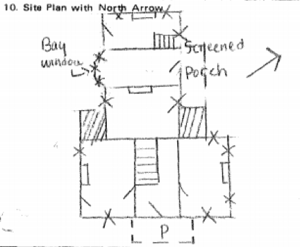
Site Layout of Bowman House
Layout of Bowman House (Source: Resources Inventory)

Property owners, according to early county maps, identify the owner in 1891 as John McMeekin who was the son of Jeremiah McMeekin. The elder was a butcher who had purchased Helm Place in 1873.

The owner in 1871 was J. S. Burrier, originally of Jessamine County, who acquired the home and 165 acres that year. He was married to Alice Craig, daughter of Lewis and Martha (Bryant) Craig.

It is believed that George H. Bowman constructed this house ca. 1860, though he remained only a few years. After inheriting Helm Place from his father, pioneer Abraham Bowman, George H. was forced to sell much of his inheritance to satisfy a gambling debt.

A. J. Reed took advantage of the younger Bowman’s misfortune and acquired the Helm Place property in 1859. It is believed that our subject house was built for George’s occupancy after the liquidation of Helm Place. Within the decade, George H. Bowman had passed away and his children divided and sold their father’s property.

Back to the present. The zoning change mentioned permitted the demolition of the Bowman House and the erection of four townhouse units in its place. It is worth noting, however, that the data relied on in the Map Amendment Request (MAR) included inaccurate data from the Fayette County PVA office.

The existing house was build in 1940, according to PVA records. Unfortunately, since the grant of the previous zone change (and prior to the purchase by the applicant) the house has fallen into a state of disrepair. There are structural issues relating to the foundation. Also contents and mechanical systems of the house have been torn out by unknown persons. Exterior decay issues are present. For all these reasons, it is impossible to preserve the house. (MARV 2013-3 Amd.pdf)

I truly doubt that preservation was an impossibility. Impracticable, perhaps. But not impossible. Several additional references existed in the MAR to the “1940 house.”

I was glad to have snapped these pictures before the old Bowman House was demolished. (I’m assuming demolition has occurred – any updates to the project?)

George H. Bowman House – Lexington, Kentucky. Author’s collection.

Interior George H. Bowman House – Lexington, Kentucky. Author’s collection.

Metes and bounds: Measuring up Kentucky

Used for centuries in England, the system of describing land by its metes and bounds is a common way of describing an area of land. Surveyors and other professionals utilize the system to specifically identify parcels of land though errors by the early surveyors creating much trouble in the early days.

Even with today’s surveys being done largely with technological advantage, it is possible for a call to be reversed and the wrong parcel be conveyed or mortgaged. The system of measured, however, is best understood by looking at the historic nature of how Kentucky itself came into being.

The Virginia Charters

In preparing for a presentation on the history of Lexington, I reviewed an online timeline of Fayette County. I’ve referenced this timeline before. It is a useful resource, but I questioned its first referenced fact when it suggested that the first Virginia charter (1606) included the territory that would become Kentucky.

Southern States of America, 1909. Available here.

Letting curiosity get the best of me, a quick Internet search offered a map of King James’ grants to the Plymouth and London Companies in 1606. As I suspected, they didn’t include the lands that would become Kentucky. A website called Virginia Places explained that the London Company “shall have all the landes, soile, groundes, havens, ports, rivers, mines, mineralls, woods, marishes, waters, fishinges, commodities and hereditaments whatsoever, from the firste seate of theire plantacion and habitacion by the space of fiftie like Englishe miles.

Additionally, the First Charter offered a company 100 miles inland from its first settlement. But 100 miles won’t reach Kentucky.

In 1609, the Second Charter extended rights of the Virginia Company to all lands within 200 miles to the north nad south of the James River. It also gave to the Virginia Company what was then unknown to be such a massive offering:

we do also of our special Grace… give, grant and confirm, unto the said Treasurer and Company, and their Successors… all those Lands, Countries, and Territories, situate, lying, and being in that Part of America, called Virginia, from the Point of Land,from the pointe of lande called Cape or Pointe Comfort all alonge the seacoste to the northward two hundred miles and from the said pointe of Cape Comfort all alonge the sea coast to the southward twoe hundred miles; and all that space and circuit of lande lieinge from the sea coaste of the precinct aforesaid upp unto the lande, throughoute, from sea to sea, west and northwest; and also all the island beinge within one hundred miles alonge the coaste of bothe seas of the precincte aforesaid. (emphasis added)

From sea to sea, eh? In these pre-Lewis & Clark days, there was still little concept of just how wide the continent truly is. The boundaries of Virginia evolved over the next century-plus before settling on the more familiar lines when, in 1784, Virginia ceded claims to northwestern lands to the U.S. government. At this point in history, Virginia consisted of the modern states/commonwealths of Kentucky, Virginia, and West Virginia.

Virginia: Breaking Up is Hard to Do
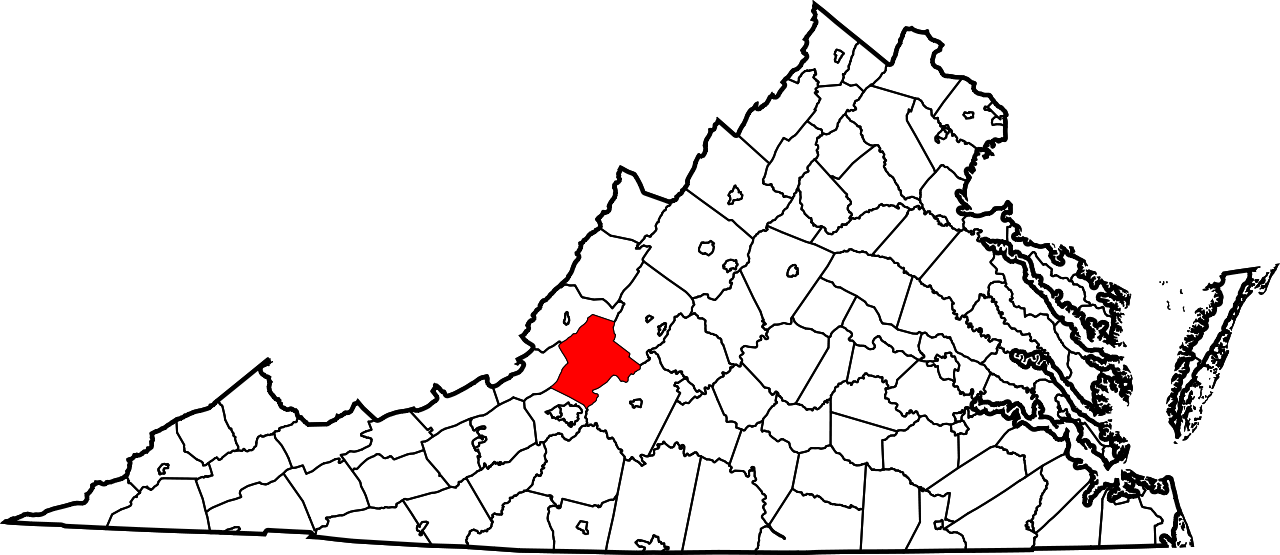
The remaining Botetourt County, Virginia. Public domain.

Kentucky arose from a still-extant Virginia county: Botetourt County which has been massively carved up over the centuries. Botetourt County was created in 1770, but the area that would become Kentucky was extracted in 1772 to become a portion of Fincastle County.

Fincastle County, which existed only through the conclusion of 1776, was carved up into three counties: Washington County (now exclusively part of Virginia), Montgomery County (which included parts of present-day Virginia and West Virginia), and Kentucky County.

Dr. Thomas Clark wrote, quoting Thomas Jefferson, that “obtaining justice should be made safe and easy as possible to all citizens.” It could be said that one reason for our declaration of independence from King George III was to achieve that dream of safe and easy justice. Of course, nothing about achieving justice has come with safety or with ease. Despite the challenges, shedding the chains of tyranny has become an American battle cry. This question framed the debate at our nation’s founding. And it framed the debate for Kentucky’s ultimate statehood.

Secretary of State.

Kentucky County survived only until 1780 when it was replaced by Jefferson, Fayette, and Lincoln counties. There was, at the time, a separate land claim for part of this area: Transylvania.

Transylvania Rises and Falls

Richard Henderson, a North Carolinian, led the Louisa Company (rechartered as the Transylvania Company) to secure the Treaty of Sycamore Shoals in a land purchase from the Cherokees. The treaty was signed on March 17, 1775, and could have given rise to the State of Transylvania, but these claims were disputed. Much of the land lied in the portion of Fincastle County that would become Kentucky County.

In 1778, Virginia invalidated all title to land arising through the Transylania Company. North Carolina followed suit in 1783. In the interim, the national government sought to clarify the boundaries in the territory northwest of the Ohio River.

To these ends, Virginia gave up its land claims in this area on January 2, 1781, but it also required Congress to take several actions including the affirmation of Virginia’s boundaries and the claims of her citizens within that area. Further, Virginia required that all other claims arising from arrangements not ratified by Virginia (read: the Transylvania Company) would be rejected.

In the end, the State of Transylvania would not rise with its validity being rejected by Virginia, the United States, and even North Carolina.

1792 and beyond

On June 1, 1792, Kentucky was admitted to the Union with the permission of the Commonwealth of Virginia. At the time, there were eight counties. Today, there are 120 counties.

The division of Kentucky’s territory into counties has not been without controversy either. Just as the separation of America from England and Kentucky from Virginia were precipitated by the need for local governance, so too was the case with the creation of many of Kentucky’s counties.

In 1798, the residents of Marble Creek labored “under great inconveniences from their detached situation from their present seat of justice.” They sought the creation of a new county. From their efforts spawned by a dispute with the leadership in Fayette County, these Jessamine Countians carved a territory Fayette.

And beginning around 1900, the people of western Carter County around Olive Hill did not appreciate the 30 or 40 mile journey to the county seat of Grayson. Olive Hill was becoming populous given the fire brick industry developing in that portion of the county. And political disputes also suggested a division. On February 9, 1904, the governor signed into law the formation of Beckham County out of portions of Carter, Elliott and Lewis counties with Olive Hill being designated as the new county seat.

Beckham County needed revenues and issued tax bills to her citizens. Mr. Zimmerman, once a resident of Carter County, challenged his $75 bill. Carter County, defending her tax base, joined with Mr. Zimmerman to challenge the constitutionality of Beckham County which was soon out of existence.

Though the name wouldn’t be known for a significant portion of the epoch, Kentucky’s geopolitical and cartographic history spans more than four centuries. Today, the boundaries are governed by Chapter 1 of the Kentucky Revised Statutes – statutes which reference U.S. Supreme Court decisions decided as late as the 1980s. And within these boundaries, Kentucky has been divided into public and private lands.

Surveyors and others have called the points which would make these divisions. Since 1983, the state legislature has authorized the use of GPS coordinates in addition to the metes and bound system which has added accuracy to the whole system.

Yes, the “sun shines bright on my old Kentucky home” as measured from the “stone at the seven pines” and beyond.