If the walls of Lexington’s Oldham House Could Talk

The Oldham House – Lexington, Ky.

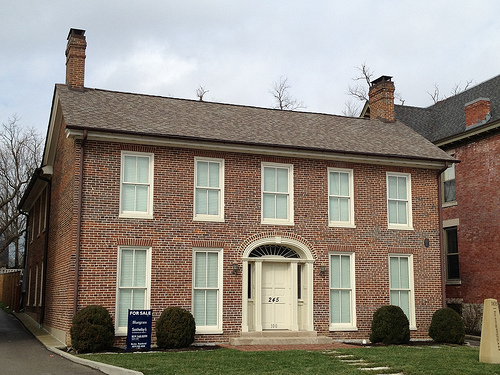
The names Samuel and Daphney Oldham don’t ring out among the most famous in Lexington’s storied history. Like many in Lexington’s early years, their stories began in Virginia. But they, and their ca. 1835 home at 245 South Limestone Street (then 95 South Limestone, or South Mulberry), represent a unique part of our community’s African-American heritage.

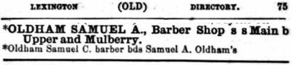
Listing from Lexington City Directory, ca. 1864

Samuel A. Oldham was an enterprising barber and business owner when he and his wife built their home on what was then Lexington’s southern edge. But at the start of the 1826, Oldham was enslaved. During the course of the year, he would purchase his own freedom. In 1830, he transacted for the freedom of his wife and sons. The freed black family thereafter built the two-story, five-bay common bond brick house.

In 1839, the Oldhams sold the home to William R. Bradford. Though they lived there only a short time, their ownership was marked as the first time a freed slave at owned a home in Lexington. In 2008, their South Limestone home was the inspiration for a one-woman act portraying Daphney Oldham. In In This Place, Daphney told her story of being born into slavery but dying as a free woman of color. The show was a collaborative effort between LexArts and director Ain Gordon; thanks be to God, Ain has published the entire performance on Vimeo:


Ain Gordon’s IN THIS PLACE… from Ain Gordon on Vimeo.

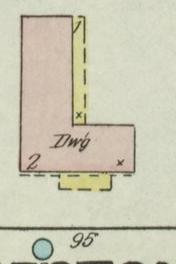
1890 Sanborn Map of then
95 S. Limestone/Mulberry

Like the Oldham’s, Bradford owned 245 S. Limestone for only a few years. It was purchased in 1845 by Juretta Shepherd,a widow, who five years later would marry Dr. Joseph G. Chinn. Attorneys kept the couple’s finances separate and it appears that Dr. Chinn, who would serve as a councilman and mayor of Lexington, never had an ownership interest in the property. Mrs. Chinn died in 1872 and the property was sold as the result of a lawsuit brought in 1877.

The property would transfer hands many times over the following century-plus. Over the years, it would be utilized as “a single family home, an antique store, apartments, and eventually a rooming house.”

The house became quite dilapidated.

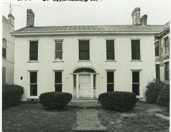
Oldham House, ca. 1965
Photo: BGT/KDL

As you can see from the ca. 1965 photo above, the old house was beginning to show signs of her age and lack of maintenance. It was listed on the Blue Grass Trust’s most endangered properties list in 2000. In 2004, the owner sought a permit to raze both the Oldham House and an adjoining structure; the Board of Architectural Review denied the request. The building was one of the most blighted structures on South Limestone; in fact, Hayward Wilkirson was quoted in a 2006 Herald-Leader article as describing South Limestone as a “gap-tooth grin” in the Historic South Hill Neighborhood. Of course, Wilkirson was referring to the Oldham House in the article entitled “Historic home needs loving owner.”

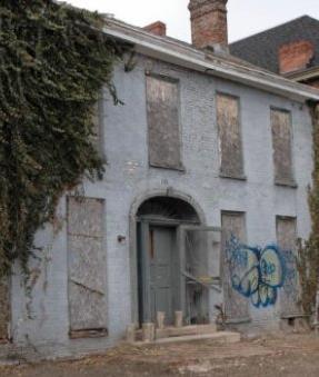
Oldham House, ca. 2007
Photo: Gilpin Masonry

A new owner was found: local builder Coleman Callaway III bought the property in early 2006 for $175,000. At that time, squatters had been the building’s most recent occupants; they had started fires to keep warm. There were holes in the roof and hardwood floors were no longer connected to floor joists or the foundation. As you can see from the photo at right, the condition of the property was nothing less than poor.

In December 2006, the home’s savior entered into a fight with the architecture review board (BOAR) over a sloped-roof addition Coleman had added to the rear of the structure. BOAR found the addition was 4 1/2 feet too wide and the sloped-roof was not in keeping with the architectural style. Seven months later, the planning commission overruled the BOAR.

An op-ed in the Feb. 4, 2007, Herald-Leader summed up the situation quite well in: “Lexington’s desire and ability to connect with the past is fantastic and, in many ways unique among growing, forward thinking cities. But our love for history and tradition should not blind us from the reality of the modern day.”

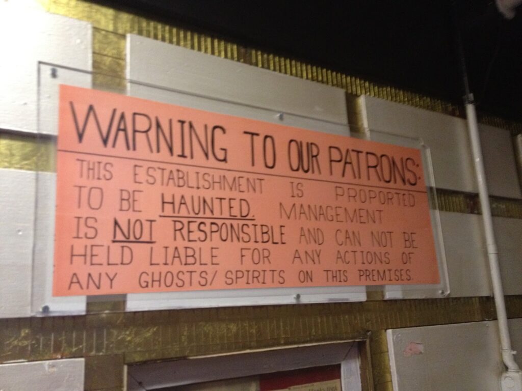
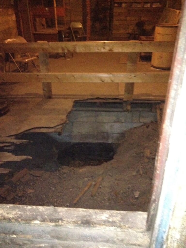
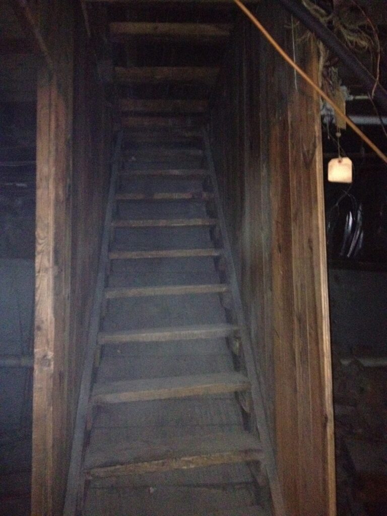
Additional photos of the deTour of the Oldham House can be viewed on flickr.

Sources: ancestry.comBGTLBAR; local.lexpublib.org; Merlene Davis (H-L); Rootsweb


The Blue Grass Trust for Historic Preservation hosts a monthly deTour for young professionals (and the young-at-heart). The group meets on the first Wednesday of each month at 5:30 p.m. Learn more details about this exciting group on FacebookYou can also see Kaintuckeean write-ups on previous deTours by clicking here.

Pappy Foreman’s Old Hickory Bar-B-Q is the Favorite of Locals in Owensboro

Old Hickory Bar-B-Q – Owensboro, Ky.

For a lot of people like me, barbecue is an intensely personal thing. I think its because of how we as a country eat barbecue – it’s an intensely American food that dates back to the Native Americans, and is usually the food that accompanies our biggest celebrations. Whether it be church picnics or family reunions, barbecue is commonly an important part of the celebration.

I was born in Kansas City and spent my first 11 years there. In Kansas City, barbecue is a form of art. My father was a barbecue junkie, and had very specific tastes when it came to who had the best ribs, baked beans, potato salad, etc.

At age 11, we moved to Alabama and my dad was shocked at how different the barbecue was. He hated it. Instead of the savory sweet Kansas City flavor, Alabama has a vinegary mustard style sauce that has a completely different flavor. Over the years, I’ve grown to love all styles of barbecue – you just have to recognize that every region has its own style, and that there is no REAL barbecue1.

Which brings me to Owensboro.

Owensboro is Kentucky’s unofficial barbecue capital. What makes Owensboro different is the primary meat: Mutton. No where else can you find barbecued mutton, and no where else can you find a better version of barbecued mutton’s most delicious offspring – burgoo. Burgoo is an old tradition in Kentucky – a stew made from all manner of ingredients brought together by a community and cooked to be eaten by everyone. Commercial barbecue began in Owensboro in 1890, when Henry Green, an African American, opened the first stand.

My wife has family in Owensboro, and while Moonlite Inn is the tourist destination for visitors, I’ve been told that Old Hickory is the favorite of the locals. It’s always been my favorite too.
Old Hickory’s burgoo is the best I’ve ever had, and the the chopped meats are awesome. You owe it to yourself to give it a try next time you’re in Owensboro. Old Hickory’s history goes back six generations to when Pappy Foreman, an Owensboro blacksmith, put down his tools and started cooking mutton back in 1918.

1 – The moderator of this site tends to agree with the author of this post; I enjoy most types of bar-b-q. I think that is because I didn’t grow up in a bar-b-q eating household. As a result, I just learned to like the dish as I experienced it. The reference to no real bar-b-q is not intended to be inflammatory (though some bar-b-q can be). Even so, pretend like the comment was so intended and defend your favorite bar-b-q in the comments.

Maps! Finding History in the Most Unusual Place: The Doctor’s Waiting Room

No one likes waiting to be seen at the doctor’s office. Although I recently visited a physician whose waiting room offered more than stale magazines. As art on the walls, the physician’s practice groups used historic maps of Kentucky, of Fayette County, and of Madison County. Fortunately, with few other patients waiting I was able to stand, examine, and photograph the historical maps of Lexington dating from 1904, 1930 and 1946/47.

1904 Map

1904 Map of Fayette County

The 1904 map of Fayette County was compiled by associate engineers J.P. Mullin and J.M. Corbin. The map noted the locations of schools, streams, and most notably structures in the rural parts of the county.

Small black squares accompanied by names of landowners revealed who lived in and around Fayette County’s lost communities. These communities, like Athens and South Elkhorn, are represented in larger typeface on the map.

A high-resolution copy of the map, though in poor condition, is also available online through the Kentucky Historical Society.

Below I have zoomed in, using the KHS map, on the city of Lexington. You can clearly see both the Kentucky Association racetrack on the city’s east side as well as the KTHBA (the Red Mile).

City of Lexington the 1904 Map

1930 Map

1930 Road Map of Fayette County

The 1930 Road Map of Fayette County was published by T.B. DeWhurst of Lexington as a road map showing the major arteries and connectors comprising Fayette County’s roads. Two tables noted the locations of “Stock Farms” and “Points of Interest.”

Most of the “points of interest” were churches, but several non-ecclesiastical sites were noteworthy. Related to Henry Clay, both Ashland and the Clay Monument at the Lexington Cemetery were considered of interest.

Two country clubs made the list as did the Iroquois Hunt Club. Two springs, the municipal water works, and Joyland Park also made the cut.

Of particular note, however, were the two airports listed. Lexington’s first airfield, “Municipal Airfield, Leestown Pike” existed on a “level pasture surrounded by trees and telephone wires.” The private field was located where the Meadowthorpe neighborhood is now located. The first municipal airport in Kentucky, also mentioned as “New Municipal Airpot, Newtown Pike” was also noted; it sat on ground now occupied by Fasig-Tipton and opened in 1930.

1946/47 Map

1946/47 Map of Lexington, Ky.

The 1946/47 map contained a great amount of detail as to the roads in central Lexington. Like the 1930 map, a list of “Noted Fayette County Farms” was included. So too was a small map of the “Highways out of Lexington, Ky.”

The map, compiled and drawn by Thomas Monson, was the only in the physician’s collection which extended to the city limits of the day. A drive out Richmond Road would reach the country after Chinoe. Near campus neighborhoods, like Clifton Heights, remained.

And the “Government Houseing Project” known as Bluegrass-Aspendale stood on the old land once occupied by the old Kentucky Association racetrack. As you can see, the housing project was segregated: Bluegrass Drives for whites and Aspendale Drives for coloreds.

Bluegrass-Aspendale Housing Project Map

Have you found history in an unusual place? Share in the comments!

More photos of Fayette County maps are on flickr.

Sources: Meadowthorpe N.A.; Tom Eblen (H-L)

“The Most Haunted Nightclub in America” is Bobby Mackey’s Music World

Bobby Mackey’s Music World – Wilder, Ky.

For those of you who have frequently read this blog, you are no doubt aware that Kentucky is a unique place. What you might not know is just how unique Kentucky is. This uniqueness dates back to even prehistoric times when even the Native Americans recognized that there was something a little bit different about this place. Native American groups didn’t really live in what is now Kentucky – it was a highly fought-over hunting ground. When settlers first arrived, they were warned by the natives that Kentucky was a “dark and bloody ground.”

In recent years, there has been an uptick in interest in all things “paranormal.” This increase in interest has been beneficial for quite a few businesses and landmarks all over the country, as haunted places have become popular tourist destinations. Perhaps as a result of its “dark and bloody” history, Kentucky has more than its fair share of paranormal destinations, including Waverly Hills Sanatorium in Louisville (which will be the subject of its own post no doubt) and Bobby Mackey’s Music World in Wilder, the self proclaimed “Most Haunted Nightclub in America.” Bobby Mackey’s has been visited by a number of now-popular ghost hunter TV shows (Ghost Hunters, Ghost Adventures, etc.), and has been able to capitalize on its dark and disturbing legendary history.

The community of Wilder sits along the Licking River, just south of Newport. When you enter the club, the sign above greets you, to let you know that your experience in this club might be a little bit different. Inside the club, you’re greeted with the sights and sounds of any country/western bar. There’s a nice size stage, and even a mechanical bull. Off to the side of the bar is a gift shop that contains the normal stuff you might see at a destination bar – t-shirts, shot glasses … and ghost hunting materials.

The history of Bobby Mackey’s is mostly culled from legend, and further reading can be found at both Bobby Mackey’s website and in Jeffrey Scott Holland’s excellent book, Weird Kentucky: Your Travel Guide to Kentucky’s Local Legends and Best Kept Secrets.

Gateway to Hell

According to legend, Bobby Mackey’s contains a “gateway to hell” which was created due to occult activity on the site. According to local legend, the site was originally the site of a slaughterhouse, and the well on-site was used to dump blood and remains into the Licking River to the west. This dumping of blood attracted the local occult and Satanic groups, which began to use the site for rituals. The story of Pearl Bryan then enters into the legend. Pearl Bryan was a 22-year old pregnant woman whose decapitated body was found near Ft. Thomas, Kentucky in 1896. Two men were tried and convicted of her murder Campbell County, and eventually both were hanged. Her sad story is pretty complicated and perhaps too disturbing for these pages, but a full account can be found here. Their trial, however, revealed the presence of Satanic groups in the area, and it is alleged that her head (which was never found) was used in a ritual at the site of the well. This well remains and is pictured at left. Allegedly, Pearl is among those who haunts the site.

Stairway to No Where

Bobby Mackey’s more recent history is closely tied to the history of Newport. As recently as a few decades ago, Newport was a pretty rough place with a significant organized crime presence. The site has for the last hundred years or so been a nightclub under a number of different owners and names. The site’s bootlegging and speakeasy history is still visible in the basement with this “stairway to no where” which sits right next to the “gateway to hell.” This stairwell was used to secretly ferry people and supplies in and out of the club during prohibition years. The basement also contains a crude jail cell, and a concrete room that allegedly is soundproof, and was the site of some pretty nasty face to face questioning sessions.

Another alleged spirit in the club is Johanna, a dancer who committed suicide by poisoning herself backstage after her father murdered her lover, who was a singer at the club. Johanna’s rose-scented perfume can allegedly be detected in different spots all over the site.

My experiences at Bobby Mackey’s were relatively uneventful, but it was still a really amazing place to visit – if just for its vivid representations of the recent shady past of this area of northern Kentucky. If you’re a paranormal junky, it’s a must see.

This Just Happened, a weekly roundup

Oliver Perry House at Camp Nelson (Jessamine Co.), now a National Historic Landmark

The nation’s most significant designation for a landmark is that of a National Historic Landmark. Kentucky has two more National Historic Landmarks: Camp Nelson in Jessamine County and Stagg Distillery in Franklin County. [Herald-Leader]

One step below a National Historic Landmark is being listed on the National Register; 28 such Register-eligible sites (including 11 in Jessamine Co.) are threatened by the proposed I-75 Connector between Nicholasville and I-75 in Jessamine County. Among the threatened sites: Marcellus Clay’s White Hall. The I-75 Corridor was one of this year’s Blue Grass Trust Most Endangered Properties. [Herald-Leader].

A number of northern Kentucky, Ohio River developments are underway or in the works for 2013. [NKY.com]

The Lexington Visitor’s Bureau has launched an awesome new website, Beyond Grits, which highlights and categorizes 106 local eateries in Fayette County. Hopefully, the LCVB keeps it up to date! [Beyond Grits]

And for curious minds, the initial development plans for Disco Kroger have been filed. [LFUCG]

It’s not Kentucky, but still interesting. Ground was recently broken on land where Harriet Tubman once toiled as a slave for a new Maryland state park to be named in her honor. [Reuters]

And further from Kentucky, English archaeologists unearthed thirteen bodies from the early days of the Black Plague while excavating for the Crossrail project, a high speed rail across London. And its not the first significant historic find during this massive underground dig. [BBC]

Federal Courthouse is of “classic architecture, according to the Greek motif”

Lexington’s Federal Building, ca. 1934. Photo: Nat’l Archives.

Since it opened in 1934, the Barr Street façade of Lexington’s Federal Building remains unchanged. Its four stories of steel, brick, and limestone construction are a classic example of federal construction in the 1930s (Neo-Classical), evincing the strength of a government and nation fighting off the consequences of the Great Depression. But even this powerful building shows signs of the era’s economics: the central eastern façade (less visible) has a less-costly brick exterior surface. In 1957, an annex was added to the federal building to better accommodate post office operations.

Lexington’s Federal Building, ca. 2013
Grand Lobby of the Federal Building – Lexington, Ky.

Flanking the building’s Barr Street frontage are two projecting pavilions which operate as the building’s primary entrances. Each admits visitors into small anterooms off the central, grand lobby. Originally, the grand lobby operated as the main post office with sorting facilities in adjacent rooms and in the basement. Today, the post office is long gone though vestiges remain in the extensively decorated room comleted with “bronze grills, marble pilasters, and a terrazzo floor.”

The eastern anteroom/lobby features “an elliptical staircase with original wrought iron balusters and a wood handrail” while the lobby has “walls of St. Genevieve Golden Vein marble.”

Courtroom A in the Federal Building, as viewed from the Bench

On the second floor is the main Courtroom A which remains as it would have appeared when the building opened in 1934, though with the addition of advanced technology necessary for today’s legal system. As described in the National Register application, it is “the most significant space of the upper floors.” The room features a “marble wainscoting, and original acoustical tile walls,” as well as original “Gothic design hanging chandeliers [having] fleur-de-lis and quatrefoil designs” hang from the coffered wood beamed ceiling.”

Ward Lockward’s
Daniel Boone’s Arrival in Kentucky

At the rear of the courtroom, opposite the judge’s bench, is a 1938 mural by Ward Lockwood entitled Daniel Boone’s Arrival in Kentucky. Commissioned by the Section of Fine Arts of the Works Progress Administration, it recalls Boone’s first crossing into Kentucky on a hunting and trapping expedition in the 1760s. Boone would, of course, return to this “promised land” calling “heaven … a Kentucky of a place.” (As legend would have it…)

Behind the bench is a portrait of Judge Cochran who was the first judge to preside in the Eastern District of Kentucky. Appointed in 1901 after the old District of Kentucky was split, Cochran would serve until his death in 1934. Flanking the walls of the courtroom are additional portraits of former and senior status judges from the District.

Grandeur of Courtroom A, as seen from the Jury Box

Building A Landmark.

North Limestone from Pleasant Green to Barr, ca. 1921
Source: Asa Chinn Collection/KDL

During the roaring twenties, Washington and Lexington leaders debated the ideal spot for a new federal courthouse in the city. City leaders opposed the federal governments proposal to erect the courthouse on Short Street at the head of Esplanade, and being owners of the property were quite persuasive.

Instead, the northeast corner of Barr and Limestone was selected in the spring of 1930 for the erection of a new federal courthouse and post office, as well as offices for other federal agencies. As a sign of the times, this included offices for the prohibition enforcement agency. The building would be located on a plot running “from Limestone east on Barr to St. Peter’s school, and north on Limestone from Barr to Pleasant Stone Street, or what is known as Sayre College alley.”

A title abstracter, J.W. Jones, was employed by the government and found “no serious defects in the titles to any property which affronts approximately 263 feet on north Limestone street and 213 feet on Barr street.” Though clearing title seemed effortless, property acquisition would not be.

In December 1930, Sawyer Smith – the U.S. District Attorney – instituted condemnation proceedings against those property owners who didn’t voluntarily sell their land. The total land value was appraised at $184,648.50; final judgment in the condemnation suit was entered in early March, 1931. On April 2, 1931, a blanket deed was filed in the Fayette County Clerk’s Office identifying the U.S.A. as owner of the land.

During the heat of late summer and early autumn, 1931, “an adequate force of workmen and equipment” from the Thurman Wrecking & Supply Co. worked to dismantle the old structures on the site of the proposed federal courthouse. But the proposal was not yet complete.
Old Federal Building at Main and Walnut

On November 6, 1931, the architect’s drawing of the “New Lexington Postoffice” was published on page one of the Lexington Leader. It was the “first official announcement of plans and specifications today.” Facing Barr street, the 170′ x 125′ structure would be “of classic architecture, according to the Greek motif.” Over the next year, the Churchill and Gillig architectural firm worked to finalize plans for the new federal building. As is often the case, it came down to the last minute. The Lexington Leader writes on March 1, 1932, “Nine draftsmen worked all night Monday  … and completed plans for Lexington’s $761,000 federal building.” Plans were then taken for a “final check by Brinton B. Davis [of Louisville], consulting architect on the project, prior to final review and approval by Louis A. Simon, Superintendent of the Architectural Division of the Treasury Department. 

With deeds acquired, land cleared, and plans approved, construction could commence! 
In December 1934, the post office and other federal offices were finally moved from the old federal building at Main and Walnut) to the new building at Limestone and Barr streets.

Postal Operations and First Class Mail.

When the Post Office opened on Barr Street, the cost to send a first class letter was 3¢. The price was unchanged when many of the post office operations were relocated in 1957 to an annex on the building’s north side. As Lexington continued to grow, the Federal Building became inadequate to serve as Lexington’s main mail sorting facility.

In 1973, the Lexington post office office was relocated to Nandino Blvd and Georgetown Road and the old post office in the Federal Building became the Barr Street Station. At the time, the cost to mail a first class letter had risen to 8¢.

Security and convenience (i.e., parking) gave way to yet another change for downtown’s postal needs in April 1998 (first class letter, 32¢) when the Barr Street Station itself was closed. Downtown PO boxes were relocated to a new, modern post office on East High Street. The modern post office, however, carries a historic name: Post Rider Station hearkening to our nation’s earliest history when mail was carried over post roads by post riders on horseback and delivered to a central location in each town or community.

Above the entry to the U.S. Marshals Office for the
Eastern District of Kentucky

Though no postal service activities remain in the Federal Building, it remains an active federal building housing the United States District Court for the Eastern District of Kentucky as well as the Office of the United States Marshals for the Eastern District of Kentucky. Among other tasks, the Marshal’s Service provides security for the federal Courts. Of course, the Marshall’s of Eastern Kentucky have been made famous by the popular FX television program Justified. Fans of the show know that Raylan Givens, a Harlan County native portrayed by Timothy Olyphant, is a U.S. Marshal. A real U.S. Marshal will advise that Givens’ office space is quite spacious and a far cry from the quarters offered the U.S. Marshals at the end of the Federal Building’s grand lobby.

Additional photos of the Federal Building may be found on flickr.


The Blue Grass Trust for Historic Preservation hosts a monthly deTour for young professionals (and the young-at-heart). The group meets on the first Wednesday of each month at 5:30 p.m. Learn more details about this exciting group on FacebookYou can also see Kaintuckeean write-ups on previous deTours by clicking here.


Sources: Andrew DartKDL (Asa Chinn)local.lexpublib.org; National Archives

This Just Happened, a weekly roundup

West Liberty’s Doughboy (WWI memorial statue) is 99% complete after it was knocked off its pedestal during last year’s devastating tornado. Once complete, the old statue will be placed in the rotunda of the new courthouse. [Herald-Leader]

On March 9, the Kentucky Military History Museum reopens after a renovation in the old State Arsenal in Frankfort. A tremendous collection of artifacts! [Herald-Leader]

Centrepointe – Prestonsburg, Ky.

Five years ago, then-Lexington Mayor Jim Newberry announced the massive downtown development that would not become CentrePointe. While the Kaintuckeean wasn’t blogging then, we’ve updated folks as what is now CentrePasture has faced evolutionary potential. A hard-handed, though thorough critique is offered by Lowell. [CivilMechanics]

And for more on CentrePointe, the legislature has modified TIF requirements to allow the downsized project to remain eligible. [Herald-Leader]

Whiskey Row may finally see some positive movement now that the stabilization work is complete. Next on the agenda is creating an entertainment destination for the Louisville landmarks. [WDRB].

A group is investigating the possibility of having Old Frankfort Pike designated a National Scenic Byway. If it occurs, it would be Kentucky’s seventh. [Herald-Leader]

Civic Center Design Proposed for Lexington. In 1923.

Rendering of Proposed Civic Center of Lexington, Ky. (1923)

Before this evening’s Blue Grass Trust deTour of the United States Federal Courthouse and Post Office, 101 Barr Street (see you there at 5:15), I wanted to explore what the area coulda/woulda looked like had Lexington had followed through on her first Comprehensive Plan.

The Plan, published in 1931, was prepared for the City Planning & Zoning Commission by L. Segoe, a consulting engineer and city planner from Cincinnati, Ohio. In 170-pages, the Plan sets forth an incredibly diverse and specific set of recommendations as well as a thorough examination of the housing, transportation, infrastructure  and aesthetics of the community. One of my favorites could be echoed again today: “An attractive street picture is incompatible with the presence of poles and wires. Streets with buildings of architectural merit should be cleared of poles and wires, as these seriously mar and may completely nullify the aesthetic value of such buildings.”  A Progressive 1931.

The Plan included reports from a 1923 study on the erection of the City Hall and the surrounding Civic Center. As pictured in the above rendering, the proposed Civic Center encompassed a number of significant structures. At the top, a proposed Greek Revival Federal Courthouse looked down an esplanade toward a proposed side for the YMCA. At the east end of Barr Street stood the old (then-present) City Hall; the clocktower of St. Peter’s Catholic Church is near the center of the rendering. As the planner wrote, “The erection of monumental buildings for governmental purposes without relation to one another, or without adequate setting, is a waste of opportunity and raises the question of the justifiability of the cost of monumental architecture.”

Layout of the Proposed Civic Center of Lexington, Ky. (1923)

This old Plan called for a beautiful Lexington and it would have been quite grand had this proposed Civic Center been completed. But, as is often the case, the “best laid schemes of mice and men often go awry.”

That esplanade was not to be and the Federal Courthouse, ultimately constructed in the neo-Classic style, was erected at Barr Street adjacent to St. Peter’s Catholic Church. The fate of City Hall would be behind a mid-century edifice that destroyed all historic beauty and caused to sorrow when it was demolished to make way for an expansion of Central Christian Church.

Left-to-right: Federal Courthouse (partial), Fayette District
Courthouse, Fayette Circuit Courthouse,
surround Robert F. Stephens Courthouse Plaza

But it is interesting to note that a grand plaza did arise, albeit nearly 75 years later, at the entry to the Federal Courthouse. The two Fayette courthouses were completed in 2001 with a spacious plaza in front. The plaza is divided by Short Street and  creates a clear view from the steps of the Federal Courthouse through Phoenix Park. The plaza is named after Robert F. Stephens, a former Fayette Circuit judge and Kentucky Supreme Court justice.

Remember: tonight at 5:15, the BGT deTour of the Federal Building.

This Just Happened, a weekly roundup

Newtown Pike is being expanded to five lanes from West Fourth to West Loudon adjacent to the new location for the BCTC community college (aka old Eastern State Asylum). [H-L]

Bishop’s House
Photo: Michael Monks, RCN.

Covington’s Bishop’s Mansion – a ca. 1830 Victorian owned for most of its life by the Catholic Diocese of Covington – was demolished this week. Fortunately, many interior features were salvaged. Replacing the historic property which is immediately south of St. Mary’s Cathedral Basilica of the Assumption will be … a Walgreen’s. [RCN]

An exploration of downtown parking woes and solutions for Lexington [BizLex]

A never opened hotel on US 27 in Jessamine County, south of Nicholasville, has been purchased and will be opened as a suite-style hotel. Scratch one off the abandoned list. [Jessamine Journal]

“Very Handsome,” Century Old Fence Removed from Eastern State Hospital Grounds

Remaining Fence at the old Eastern State Hospital – Lexington, Ky.

On Tuesday morning, only about 100 feet of the old iron fence that enclosed the old Eastern State  Lunatic Asylum remained. The great Lexington Land Swap is nearing completion and BCTC will soon be moving into its new campus at Newtown Pike and West Fourth Street.

In early 1905, the fence separating those two streets from the ‘lunatic asylum’ was a “high board fence” … “an eyesore for years” which “obscur[ed] from view the beautiful grounds of the institution.” While one would not ordinarily consider the grounds of an asylum for their beauty, the institution’s 1869 annual report described the “pleasure grounds” as providing “with seats, arbors, flower gardens, swings & ca., are extensive, and are growing more beautiful every day.”

Original Retaining Wall Along Fourth Street

And so it was approved that a six foot high, “very handsome” iron fence would replace it. The contract was awarded to the Stewart Iron Works of Cincinnati at a cost of approximately $3,000.

The beautiful fence on the asylum’s most prominent corner also bordered what would have been the original acreage of the institution. The asylum’s original ten acres were located where Fourth Street joined Newtown Pike (nee Henry’s Mill Road) (Fayette DB W, P158).

A widening, however, of Henry’s Mill Newtown Pike required the fence’s removal. In snapping pictures, I observed that careful attention to detail was being taken in cataloguing the old fence. Neat pallets of iron fencing were stacked along the grass and a forklift was placing them onto a flatbed. The markings on the cab of the flatbed: Stewart Iron Works.

Numbered Post 308
   
Loading onto a Stewart Iron Works flatbed

Stewart Iron Works, “a tradition of excellence since 1862,” confirmed that the fence which the company originally fabricated was being taken to its shop in Erlanger “for sandblasting, repair, E-coating (primer) and powder coat (top coat).” After its restoration, the original fence will be re-installed “in its original condition along a new retaining wall that is to be built.”

It is anticipated that the historic fence will return to the property, along Fourth Street only, sometime in late 2013.

More photos on flickr.

Sources: Asylum Projects.org; KY Archeological SurveyLexington Leader; Stewart Iron Works