Forsythe-Shewmaker House in Mercer County on National Register

Forsythe-Shewmaker House – Salvisa, Ky.
Photo: NRHP Application, Ky. Heritage Council

On the banks of the Salt River in Mercer County, Andrew Forsythe built his two-story brick home as the centerpiece of his farm around 1830. In the Federal-Greek Revival style, Forsythe’s home also incorporated a number of French considerations which would have been quite en vogue at the time such as the parlor wallpaper being imported from Paris.

Forsythe was born in 1795 in Mercer County. He was the grandson of one of the five McAfee brothers who settled the area around what is now Salvisa. From the age of 17, Forsythe ventured in the transport of goods utilizing the many waterways around Mercer County. He would often “fill a flat boat at Oregon with produce, take it down to New Orleans, sell it and then walk home.” He would also transport items via horseback to eastern Kentucky and to Maysville by road.

Forsythe took to farming in 1820 and by 1832 had amassed 250 acres along the Salt River. Eventually, his holdings would include 693 acres before he died in 1886 at the age of 91.

Forsythe’s home, known now as the Forsythe-Shewmaker Home, was recently listed on the National Register of Historic Places. Just shy of 19 acres remains part of the property. One of the notable points in the nomination form is how the structure and design of the home lent to impress others and to improve Forsythe’s social position.

The application points specifically to the one story brick servants home built in close proximity to the main house. In the 1830s, having two brick structures so close together was significant and showed Forsythe’s importance in the local economy.

The Shewmaker name is added to the identity of the home because that family bought the dilapidated house in 1937 at auction on the courthouse steps in Harrodsburg, restored it and held the property until 1976.

On a personal note, I’m quite fond of this area as it was where I took my first No Destination drive, including a visit down to the dock at Oregon where Forsythe’s career was forged. Much of the family, including Forsythe’s father, worshipped at New Providence Church and is buried in the church cemetery.

Source: Ky. Heritage Council NRHP Application

Lexington’s History Encapsulated in First Presbyterian Church

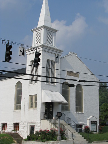
First Presbyterian Church – Lexington, Ky.

Under an old Virginia law, the city or town acting as county seat could only have a church of the Anglican persuasion within her limits. Baptists, Methodists, Presbyterians and others located their houses of worship outside of the city limits in order to circumvent the establishment law.

In 1784 Virginia, the area known as Kentucky today remained part of Virginia. Lexington had already been established as the county seat of Fayette and thus the establishment law applied here as well. Circumventing it, the people of Mount Zion Presbyterian Church established their church home beyond the city limits on a 190-acre tract in the vicinity of today’s Agriculture Experimental Station at the University of Kentucky, near the corner of South Limestone and Huguelet.

Mt. Zion counted among its members some of Lexington’s most prominent eighteenth century names: Robert Patterson and John Maxwell. By 1792, a location closer to town was sought and found by the courthouse square at Cheapside. Yet it was the same convenience and centrality which brought the Presbyterian congregation to the center of town that took it away — the noise was just too great. So in 1808, the church again relocated to the corner of Broadway and Second streets where it constructed a temporary one-story meeting house.

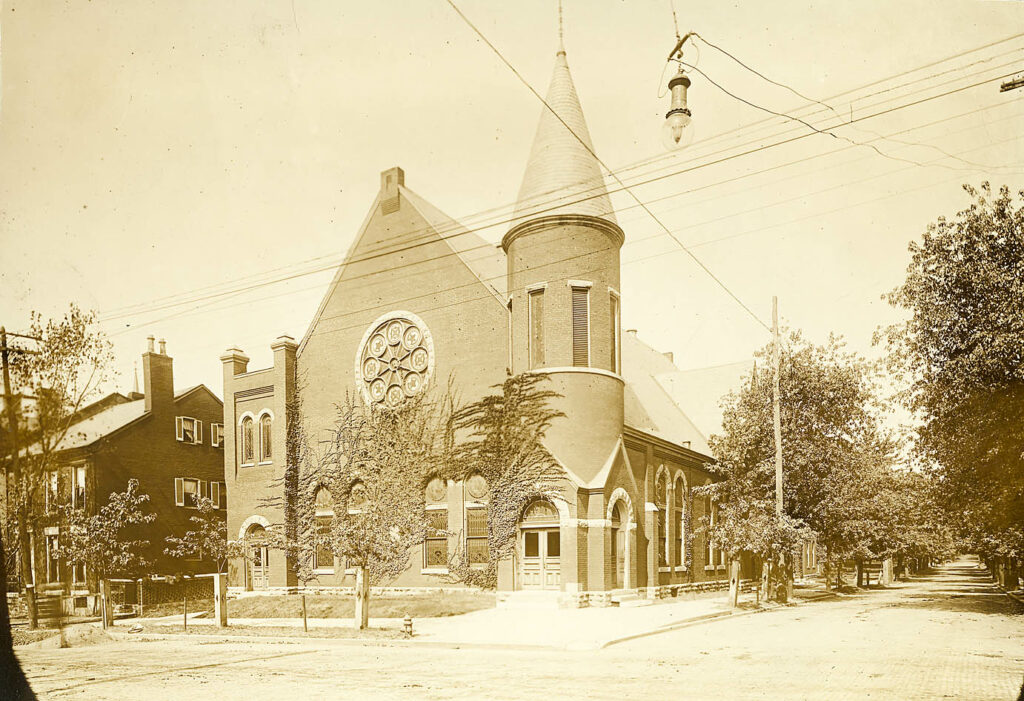
First Presbyterian Church, later Broadway Christian
Photo: Louis Edward Nollau (KDL)

During an 1817 service at the old meeting house, two women visiting (but not having joined) First Presbyterian were struck and killed by lighting. The following week, another church’s minister proclaimed it a classic lesson in procrastination and urged quick heed.

Benjamin LaTrobe was contacted and consulted for the erection of a new house of worship. Plans were drawn, but the vision never completed. Instead, a two story brick church was built on the same location in 1857. When First Presbyterian (as the congregation had been remonikered) left Broadway in 1870, the incoming Broadway Christian Church took its place where the first sermon pronounced it to be the “first Christian sermon to be preached in this building.”

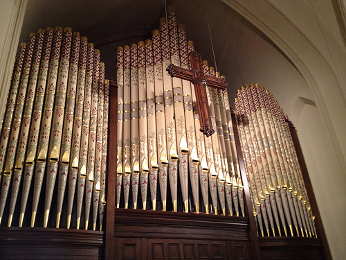
Organ at First Presbyterian – Lexington Ky.

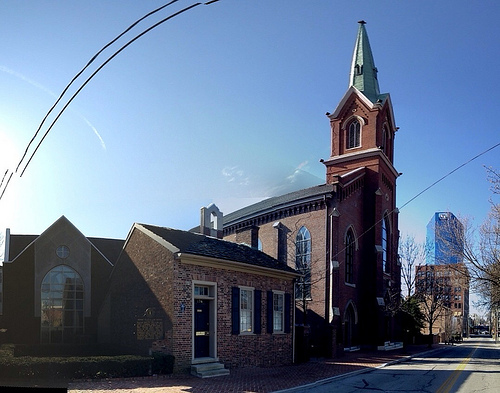
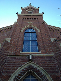
Until the new church on Mill Street was completed in 1872, the First Presbyterian congregation met in the Melodeon Hall on Main Street.  Originally four bays deep, the First Presbyterian Church on Mill Street cost approximately $338,000 to construct. It is a beautiful construction in the Gothic style and it was designed by Cincinnatus Shryock. It prominently features an eighteen foot square, 180 foot tower/spire at Mill Street while its Market Street side was added on in 1897 to add a fifth bay as well as the wonderful Kimble organ. The organ pipes were recently discovered to have been originally stenciled and this design has been reincorporated.

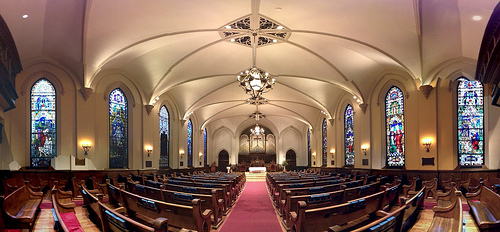
First Presbyterian Church Sanctuary – Lexington, Ky.

The ten stained glass windows are each unique and were installed over a number of years following the 1897 addition. Money for these improvements came from pew rentals, while the loose plate offerings were used for incidentals and to aide the poor.

First Presbyterian Church

First Presbyterian (k/a Mt. Zion)’s first minister was Adam Rankin. A great speaker, but highly opinionated, Rankin shared his duties between the Lexington church and the Woodford County congregation as Pisgah.  Controversially, he withheld communion from parishioners who liked Isaac Watts’ paraphrased hymns (the lyrics paraphrased scripture). Ultimately, the Transylvania Presbytery removed Rankin from the pulpit.

Another noted minister was Rev. Robert J. Breckinridge who was known as the “Napoleon of the Pulpit.” Serving from 1847 to 1853, Breckinridge was known for his strong favor of education. For his views, Governor Owsley (a very pro-education governor) named him Kentucky’s first superintendent of public instruction.

The Civil War found a splintering First Presbyterian Church as its members loved the Union but wanted to keep their slaves. By the end of the war, however, the split couldn’t be avoided. The suspension of habeus corpus and emancipation caused a major rift in the congregation and the congregation of Second Presbyterian. From 1866 until the 1880s, each of the two churches had two separate congregations with separate ministers with each aligning with either the northern or southern wings of the Presbyterian church.

The two wings of the Presbyterian Church were reunited in 1968 and the church remains one of Lexington’s finest. The church’s duration and functions (e.g., John Cabell Breckinridge’s 1875 funeral) have witnessed nearly all of Lexington’s storied history.

ky360: First Presbyterian Church
Flickr Photo Album of First Presbyterian Church

Sources: deTour; First Pres. Church HistoryKDLNPSNRHP


The Bluegrass Trust for Historic Preservation hosts a monthly deTour for young professionals (and the young-at-heart) to a local historic site that has been well-preserved and restored – the group meets on the first Wednesday of each month at 5:30 p.m. Details are always available on Facebook! Our next meeting is Wednesday, April 4 where we will explore the North Limestone neighborhood! Join us by meeting at Al’s Bar!! You can see Kaintuckeean write-ups on previous deTours by clicking here.

Gr8ness! GO Big Blue! #BBN

Senior Night (2012) – Rupp Arena, Lexington, Ky.

Tonight, the University of Kentucky Wildcats will face the Jayhawks of Kansas in the National Championship game. Having defeated two Kentucky schools en route (Western Kentucky and Louisville), only one more hurdle stands in the way of bringing Kentucky back to hang a NC banner. GO CATS! 

I’ve missed writing and I’ll be back soon. I promise. Problem is, there have been a few things that have gotten in the way. Early spring. Basketball. Family.

Yes, I confess. I cannot make the blog first in my life, but I’ll get it back on the agenda. That’s what April is for. Until then, love Kentucky and remember: Louisville Sucks.

Join Kaintuckee’s Bracket Challenge!

Rupp Arena

Ready to bleed blue?  March Madness is upon us. Join the Kaintuckeean March Madness Bracket Challenge (for the pride of being the greatest Kaintuckeean since Ali) at ESPN by clicking here.

No cost. Just fun. And since we are Kaintuckeeans, we have a lot of fun basketball to watch! Remember:

One Commonwealth. One #1 in the Nation. Two Top 10s. Three Top 25s. Four Teams in the Tournament. The Fourth Team just played in front of the President and British Prime Minister in an awesome comeback. 

I love March! So join in on the fun with the Kaintuckeean Bracket Challenge!

ky360: First Presbyterian Church Sanctuary in Lexington

Last Wednesday, the Blue Grass Trust deTour to First Presbyterian Church revealed a beautiful sanctuary and other fascinating bits of history. I’ll post soon, but check out this ky360 panorama taken from the rear of the sanctuary of the North Mill Street Church.

On another note, there is a tremendous amount going on right now so posting will be more sporadic and limited for the next few weeks. Blame me… and basketball!

Looking West from Lexington’s Oliver Lewis Way Bridge

Oliver Lewis Way Bridge – Lexington, Ky.

At the western edge of the Rupp Arena is the Manchester Street parking lot. This parking lot travels under the Jefferson Street viaduct before coming to an end near the new bridge at Oliver Lewis Way. Although the bridge is rather nondescript, the view from it can be described as anything but.

In Lexington’s never-ending labyrinth of street names, the parking lot was once known by Cox Street because that was the road that extended Newtown Pike from Main Street to High. A rebuilt Newtown Pike Extension was renamed Oliver Lewis Way (slightly west of Cox Street) in time for the 2010 World Equestrian Games. The extension is a fantastic bypass of downtown which I’ve utilized many times, though recently on foot for the first time.

I knew, but hadn’t ever taken the time to notice, all of the activity that occurs on the western side of the bridge:

Panoramic View, facing west, from Oliver Lewis Way Bridge – Lexington, Ky.

All visible are the Distillery District, the Town Branch Creek and the RJ Corman Railyard. About 100 years ago, much of this was open land to receive seasonal flooding of the town branch. The bridge today sits largely over the building and the “s-curve_” in the Town Branch as seen in the 1907-1920 Sanborn Insurance Map below. The building was industrial in nature – the home of the Waller Manufacturing Company, Planing Mill and Hogshead Mfy. A hogshead was a large (225 litre) wooden barrel used typically to hold tobacco or, more importantly given the proximity to several Lexington-based distilleries, to age bourbon.

Sanborn Insurance Map (1907-1920); Source: KDL-KYVL.

The Town Branch Creek which forms the axis on which Lexington is designed flows underneath Lexington (since we buried it). Efforts are underway as part of the Arena, Arts, and Entertainment Taskforce to raise the Town Branch Creek back to the surface. But, looking west from the Oliver Lewis Way Bridge one can already see the Town Branch Creek working its way toward the Kentucky River and beyond:

Town Branch Creek – Lexington, Ky.

Finally, I could spend the afternoon watching the happenings at the RJ Corman Railyard. The coupling and uncoupling of trains and the unloading of freight (often, river sand harvested from near Louisville) is an incredible sight. Corman’s holdings (a lot of land and facilities at its headquarters in Nicholasville, a major derailment division, and the My Old Kentucky Dinner Train among them) all are well-kept and contribute to the beauty of the region. That is something you cannot say about many short lines around the country. Consider the display at the southwest corner of Main and Newtown Streets featuring fence, a stone wall, cab, car and caboose:

RJ Corman Railyard – Lexington, Ky.

There is a lot to see from the Oliver Lewis Way Bridge, but you must take the time to observe it. And I’m sure in my few minutes that I missed a lot. What else do you see?

Paducah, Ky. Neighborhood, Wallace Park, Added to National Register

Tree-lined streets of Wallace Park Neighborhood Historic District
Photo: Ky. Heritage Soc., NRHP Application 

The National Park Service listed Paducah’s Wallace Park Neighborhood Historic District on the National Register of Historic Places on February 22, 2012. The district was recommended by the Kentucky Heritage Council in December.

Development of Wallace Park began in 1923 as an affluent residential neighborhood and it thrived as a middle- and upper-class subdivision after incorporation into Paducah’s city limits in 1926. The district consists if approximately 75 acres, including 154 of 159 structures being contributing.

Wallace House – 203 Cedar Lane – Paducah, Ky.
Photo: Ky. Heritage Soc., NRHP Application

The oldest structure, the Wallace House, was built ca. 1860 by Captain Phillip Wallace and his wife and is “the iconic symbol of Wallace Park.” “The Greek Revival structure is a five- bay, central passage structure laid in seven-course, common-bond masonry and covered by a hip roof. The side and rear of the structure are enclosed with several additions.” In 1890, Capt. Wallace sold his home and the surrounding acreage to the City Transit Company who developed the property into a recreational, family getaway (accessible, of course, by trolley).

Originally known as LaBelle Park, the site included a nine hole golf course, dance pavilion, lake, and a zoo. The park – then about a mile west of Paducah’s city limits – also had a casino!!

Around 1904, baseball diamonds and bleachers were added and the park was renamed Wallace Park. A minor league baseball team (Kitty League) called it home from 1904-1908. Interest in the park, however, fell by the early 1920s.

Survey of Wallace Park – west of Paducah, Ky. (June 1923)
Source: Ky. Heritage Soc., NRHP Application

Before the neighborhood was developed, the land was offered by the city to the state to be the site for a new college in the Purchase area. Instead, in 1922, the state legislature selected the town of Murray as the home of the new western normal school. At the same time, an eastern normal school at Morehead was also established.

Once a neighborhood was planned, Tudor Revival and Craftsman Bungalow style homes were constructed in the mid-1920s. These were followed by the construction of Cape Codders and Colonial Revivals. In the 1950s, a housing boom prompted the construction of several duplexes. The last homes in the neighborhood were built in the 1980s.

The neighborhood is a microcosm of Paducah’s own development during the twentieth century. Further, the integrity of the neighborhood is strong due to design requirements, setbacks, and minimum housing prices since the earliest days of Wallace Park. It is a beautiful neighborhood with a variety of architectural styles, established trees, and significant character.

Source: McCracken Co. HistoryNRHP Application, #12000047; NRHP Listing; Paducah Parks History

Tornado Hits West Liberty, Kentucky: Before & After

Aerial from WKYT-TV

In 62 years, Morgan County experienced three tornados. But in the past three days, the same county has experienced two. * The tornadoes have been absolutely devastating with incredible property damage and, more importantly, loss of life. My heart aches as I lift up my prayers for all of those who were affected in West Liberty and beyond.

I was fortunate enough to visit West Liberty during the summer of 2011 and see part of this beautiful eastern Kentucky town. Following my visit, I profiled the Judge John E. Cooper House which was built in 1872/73 as well as the Millstone Monument on the Courthouse Lawn. Nate has also profiled the Morgan County Courthouse (1907).

For Jake of PageOneKentucky, it is particularly personal as he is a native of West Liberty. His immediate impression this morning, on the ground:

Is that it’s not just a few roofs ripped off. Telecommunications infrastructure is dead at the moment. There are maybe two buildings in town that are structurally sound. The rest are gone or just a few walls remain. Funeral homes are gone. Most pharmacies and stores are gone. Gas stations demolished. Flooding is separating part of the town. The hospital was severely damaged. Schools damaged.

We echo Jake’s plea: If you have a dollar, DONATE IT HERE (RED CROSS).

For perspective, I’ve pulled some photographs that I took last summer with those now available.

West Liberty United Methodist Church

Church - West Liberty, Ky.
West Liberty United Methodist Church (July 2011)
Tornado Damage in West Liberty, Ky.
West Liberty United Methodist Church (March 2, 2012)
Photo: Kristen Kennedy, WKYT-TV. Used with permission.
Kentucky Leadership assesses West Liberty, KY
West Liberty United Methodist Church (March 3, 2012)
Photo: Ky. Nat’l Guard Public Affairs Office

Main Street – West Liberty
For perspective, look the awnings of the building at the far-left of each photo.

West Liberty - Ky.
Main Street – West Liberty, Ky. (July 2011)

Main Street – West Liberty, Ky. (March 3, 2011)
Photo: Jason Coffee, from pageonekentucky


World War I Memorial
On the lawn of the old courthouse stood a WWI soldier as a memorial to those brave men who served their country during the Great War. As you can see, only the base remains.

West Liberty - Ky.
Morgan Co. World War I Memorial (July 2011)
DSC_8724
Gov. Beshear Viewing Damage; WWI Memorial at right
Photo: Ky. Nat’l Guard Public Affairs Office

Old Courthouse

The old courthouse was built in 1907 and its listed on the National Register of Historic Places. A new judicial center (condition below) has been under construction immediately behind this building. Early reports were that this building was flattened – clearly not accurate – but it is uncertain whether the damage sustained will warrant demolition or whether it can be saved. It is clear, by comparing Nate’s picture (#2) with the after-storm photo that the beautiful cupola is gone. In discussing the damage with Nate, we agreed that Morgan County’s was one of the most beautiful courthouses in eastern Kentucky.

Morgan County Courthouse - West Liberty - Ky.
Old Courthouse – West Liberty, Ky. (July 2011)
Morgan County Courthouse - West Liberty, Ky.
Old Morgan County Courthouse with Cupola
Photo: Nate Kissel

DSC_8721
Old Courthouse (March 3, 2012)
Photo: Ky Nat’l Guard Public Affairs Office

New Judicial Center
Not yet complete, the new judicial center appears to have sustained a lot of damage.

West Liberty - Ky.
New Judicial Center (July 2011)
Tornado Damage - West Liberty, Ky.
Aerial Photo of Tornado Damage – West Liberty, Ky.
TV Screenshot of WKYT-TV Skyfirst (March 3, 2012)

All of my Morgan County photos are available on flickr.

Lexington’s Centrepointe Design Almost a Reality? Feels like it.

Proposed Design of Centrepointe Block – Lexington, Ky.

After last night’s public meeting, I am convinced that 2012 will be the year that ground is broken on the Centrepointe project. With the likes of Marriott, Urban Active, Jeff Ruby’s, Saul Good and others being (repeatedly and publicly) linked to the project, it is hard to comprehend that the developers would not be nearing shovel readiness. Yes, ink must be dried, permits and governmental authorizations attained … but by and large, I think we are ready to move forward.

And that will be a good thing. I’ve commented on the Centrepointe saga several times before (hereherehere, and here among others) and I’ve only been a small voice. But the collective voice of many has improved the design of the property from its earliest forms to what we see today.

E pluribus unum. Out of many, one.

Great credit should be given to the property owners for opening up a dialogue about the design of the property even though they have received great criticism. Public comment continued last night at a forum while email comment is being continuously accepted at [email protected].

Great credit should be given to the architects involved – all of them – who have listened to and, as appropriate, incorporated suggestions from the public.

From last night’s public meeting, I did glean a few details about the overall project that were not known last month when the initial renderings of the EOP (the primary architectural firm involved) were released. (See Another Round in the Centrepointe Saga, Feb. 16, 2012) But mostly, these were small details.

In my earlier post, I saw inspiration for the building at Vine and Limestone as being a bird’s nest a la the Beijing Olympic Stadium. Apparently, I was wrong. The building was inspired by a Kentucky forest with its trees strongly reaching upward. The rooftop garden completes the canopy. Okay!?

Anyway, the main thing from yesterday was seeing all the renderings. And there were a lot of them! Here is some of what I saw:

Centrepointe Rendering - Lexington, Ky. Centrepointe Rendering - Lexington, Ky. Centrepointe Rendering - Lexington, Ky. Centrepointe Rendering - Lexington, Ky. Centrepointe Rendering - Lexington, Ky. Centrepointe Rendering - Lexington, Ky. Centrepointe Rendering - Lexington, Ky. Centrepointe Rendering - Lexington, Ky.
All great! Two notes from these photos. In the second to last, we see a pedway over Upper Street that likely won’t survive the CADRB and I understand that the exact schematics of the pedway are yet to be finalized. We’ll see. More importantly, in the last photo I’m concerned about the vehicular traffic flow into the hotel. It seems that there are some very dangerous points with the up/down ramps as traffic comes in off Vine Street; also, I’m afraid traffic would become congested on Vine as many people arrive for a conference, etc. Just my two cents.

And now for my funny observation of the evening: the schematics indicate that most of downtown is being overrun by either Transy or UK. The Student Center is EVERYWHERE!
Centrepointe Rendering - Lexington, Ky. Centrepointe Rendering - Lexington, Ky. Centrepointe Rendering - Lexington, Ky.