kernel: 9/11 Memoriam

LCA - Lexington, Ky.
Lexington Christian Academy – Lexington, Ky.

After 9/11, country musicians quickly wrote new songs. Some embraced a militaristic perspective, suggesting that the “American Way” was “putting a boot in your ass.” (Toby Keith). Others recognized the importance of the moment – like Pearl Harbor or the JFK assassinations for earlier generations – where all would remember where they were “when the world stopped turning, that September Day.” (Alan Jackson).

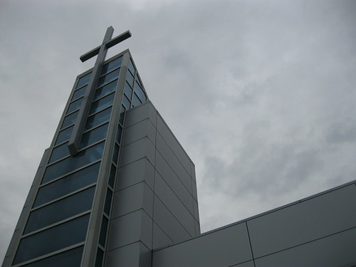
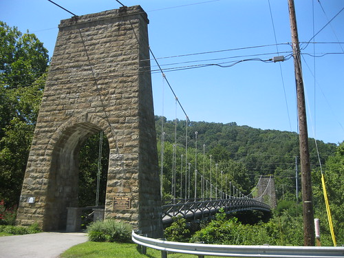
For me, I was 18 – a senior in high school at Lexington Christian Academy. Between first and second periods, a friend met me in the front hallway under the pictured tower of glass and steel. He told me that a plane had hit the World Trade Center. I immediately dismissed this as likely only an accident with the same effect as the Cessna that had hit the White House in 1994.

By the time I arrived in second period, the south tower had been struck by United Flight 175. I knew then that America was under attack and that this was no small accident. In horror, I sat in a classroom of scared 17 and 18 year olds as we collectively watched  the south tower fall.

Some of us thought of a military response and were concerned about the return of the draft; several in my class have served in the decade since 9/11.

Our school did not close on 9/11. A few teachers maintained ordinary class schedules, but the day was anything but ordinary. As you can image, a lot of prayers were offered at a Christian academy.

NoD: The Graves of Seven Who Fell in ‘The Masterful Retreat’

Rural Cemetery - Elliott County
Unmarked Grave – Elliott County, Ky.

Momma always instructed us not to “cut off the hand that feeds you.” This old maxim shouldn’t be forgotten in life or in battle.

The Cumberland Gap was a strategic link through the Appalachians during the Civil War and control of it was a constant struggle. After the battle of Ivy Mountain, Union troops became increasingly bold in southeastern Kentucky. By the middle of 1862, General George W. Morgan saw his opportunity to take the Cumberland Gap. To do so, however, he (and his men and their artillery) had to cross very rugged terrain. The end result was a loss of their supply line.

By June 17, 1862, General Morgan had taken control of the Cumberland Gap, but his men were relying on foraging for their rations. After taking the Gap, General Morgan wrote to Secretary of War Edwin Stanton: “The enemy evacuated this American Gibraltar this morning … and DeCourcy’s brigade took possession.” Gibraltar being, of course, a reference to the straight by which one enters the Mediterranean Sea.
Ultimately, however, the Confederate Army sought an invasion of Kentucky (ultimately leading to the Battle of Perryville) through Tennessee. With no supply line and the threat of being surrounded by rebel forces, General Morgan abandoned the Cumberland Gap on September 17, 1862 and began what would be known as “The Masterful Retreat” toward Grayson, Kentucky.

Along the way, the Union troops under Gen. George Morgan were under constant threat from the tactics of CSA Gen. John Hunt Morgan and his 1,200 cavalry riders. As USA Morgan’s 7th KY Division made its retreat to Grayson, a constant calibration of security tactics was necessary because of CSA Morgan’s guerrilla-like ambushes. The only “roadway” through Elliott County wide enough for the 7th KYwas the riverbed of the Little Sandy River, which flowed through many gorges and narrows perfect for ambush.

It was said the the rebels “fought vigorously with ax and torch, felling trees, barricading the road, destroying bridges, and making every barricade cost a skirmish and time.” At one such skirmish, seven men of the Union’s 7th Kentucky Division fell and are buried in this little cemetery located two miles south of Sandy Hook.

It is likely that this cemetery also served as a family cemetery for local residents as there are more than seven graves present. Today, as is the case with so many Civil War sites, this rural corner of Elliott County is being developed, but a roadside marker (“Skirmish Here“) records the spot in the annals of history.

The remainder of the 7th Division arrived in Grayson after a grueling 16 day march.

More pictures are available here.

Bibliography

EV – Buffalo Trace Distillery, Frankfort, Ky.

Buffalo Trace Distillery – Frankfort, Ky.

A few months ago, I was lucky enough to attend a wedding at the Buffalo Trace Distillery, (allegedly) the oldest operating distillery site in the country. Located in Frankfort, the site is on the National Historic Register as the George T. Stagg Distillery. Distilling began on this site sometime before 1773, on the site of an old trail (the Alanant-O-Wamiowee) where Buffalo reportedly crossed the Kentucky River. These Buffalo trails or “Buffalo Trace” were used by early pioneers.

Buffalo Trace bourbon, introduced in the late 1990s, is merely the most recent bourbon to be manufactured here. Many different distilleries have operated on the site over the years, and the oldest standing building on the site dates to 1792. The grounds are quite beautiful, and definitely worth a visit next time you’re in the Frankfort area.

NoD: Battle of Ivy Mountain

Battle of Ivy Mountain - Floyd County, Ky.
Ivy Mountain Memorial – Floyd County, Ky.

In the fall of 1861, General William Tecumseh Sherman, then the head of the Department of the Cumberland, heard rumors that a concentration of Confederate troops was amassing at Prestonsburg. In response, Sherman ordered Brig. Gen William O. “Bull” Nelson from his station at Maysville who was joined by Louisa-based Colonel Joshua Sill in driving Confederate forces south through Hazel Green and West Liberty.

Always short on supplies, Big Sandy Valley Confederates were also running short on ammunition in Prestonsburg. Under the direction of Capt. Andrew Jackson May, the men fell back on November 5, 1861, toward Piketon (n/k/a Pikeville). In Pikeville, the majority of the region’s Confederates were stationed under Col. John S. Williamson.

On November 8, 1861, May’s men took a stand to slow the southerly advance of Union forces. A volley temporarily halted Union troops, but reinforcements quickly overwhelmed May’s ragtag Rebels who retreated toward Virginia.

Confederate forces under Captain May left in their wake fallen trees and burned bridges, slowing the Union’s eventual taking of Piketon. Effectively, this was the end of the fight for the Big Sandy Valley as the mountains of eastern Kentucky were a Union stronghold for most of the Civil War.

Casualty counts from Ivy Mountains differ, but most reports indicate that Union forces suffered 30 casualties (6 killed; 24 wounded). Colonel Williams wrote of the Confederates’ loss: “10 killed, 15 wounded, and 40 missing. Some of the missing men have gone back to their homes, and others join us daily.” Most notable among Rebel losses was the state senator from Greenup County, Kentucky, Lt. Henry M. Rust “who fell gallantly in the discharge of his duty.”

“Bull” Nelson died in 1862; Jessamine County’s Camp Nelson was named in his honor, as is the adjacent national cemetery.

The monument to the Ivy Mountain battle sits adjacent to US 23 was dedicated in 2001 on the 140th anniversary of the conflict. In a few months, the sesquicentennial will be celebrated. The monument is a fifteen foot tall obelisk over an engraved base. As you can see from the picture, Ivy Mountain has been cut away to create and widen US 23. Without a thought, you know that the location is nothing like that seen by General “Bull” Nelson, Captain May, Senator Rust, and the others involved in the conflict. But, a rugged, narrow trail sweeps down toward the banks of the Big Sandy River. With the trees, the brush, and the passing waters of the Big Sandy, the past is much easier to imagine.

More photographs of the Ivy Mountain Memorial can be viewed on flickr.

Bibliography
Eastern Kentucky and the Civil War
Kentucky Encyclopedia
National Park Service

EV: Lexington National Cemetery (Lexington Cemetery, pt. V)

As I mentioned in an earlier post, there are three national historic sites within the Lexington Cemetery. The largest of these is the Lexington National Cemetery. It is one of eight national cemeteries in the state.

During the Civil War, 965 Union soldiers were buried in the Lexington Cemetery. Confederates were buried in an adjoining lot. After the war, the Union lot was donated by the cemetery company to the federal government, which also purchased an adjoining 16,111 square feet in 1867. The whole area was designated a national cemetery and federal soldiers from several surrounding Kentucky counties were brought there to be buried. By 1932 the area was filled, and an additional adjacent lot was eventually purchased.

walkLEX: Prayer Garden in the City

Prayer Garden (Central Christian Church) - Lexington, Ky.
The Prayer Garden at Central Christian Church – Lexington, Ky.

I immediately thought of the first verse and chorus of C. Austin Miles’ 1912 hymn, I Come to the Garden Alone, when I walked into the prayer garden nestled outside Lexington’s Central Christian Church:

I come to the garden alone / while the dew is still on the roses / And the voice I hear falling on my ear / The Son of God discloses / And He walks with me, and He talks with me / And He tells me I am His own / And the joy we share as we tarry there / None other has ever known.

The entire concept of a prayer garden — a quiet, outside place designed entirely for reflection and contemplative thought — is one of my favorite church design features. Of course, a well-designed park can also provide a reflective and contemplative place to tarry.

The prayer garden at Central Christian Church is narrow and long. Walking up the pavers toward a statue of Jesus – his arms outstretched – is welcoming. Two benches sit for those wanting to linger. Although plantings were at a minimum, the simplicity of the design felt complete. Visible from Short Street, the garden provide a place of “rest… in the midst of onrushing and noisy living.”

Incomplete was the statue of Jesus. Whether the result of weather or vandalism, Jesus was missing an arm and on the other, a thumb. The statue, carved of carrara marble in Carrara, Italy, is a reproduction of The Christus which stands in the Church of our Lady of Copenhagen, Denmark. The sculptor of the Danish Christus was Bertel Thorvaldsen (1770-1844); it depicts Jesus after the resurrection when he is calming his gathered disciples. “Peace be with you.” As legend goes, a man was disappointed upon seeing the statue but was reassured by a newsboy who told him, “Mister, you really can’t see his beauty unless you get down on your knees and look up into his face.”

More pictures of Central Christian Church’s Prayer Garden are available on flickr.

NoD: Prater’s Fort, Pioneer Village and a History Remembered in Salyersville

Prater's Fort - Salyersville, Ky.
Prater’s Fort – Salyersville, Ky.

Despite being one of America’s poorest counties, Magoffin County has not forgotten her rich history. The county’s historical society is incredibly active from its location in the old Salyersville post office on Church Street.

Adjacent to the historical society’s offices is a recreated pioneer village with fifteen authentic log buildings that have been collected from around the county and rebuilt at the site. Inside the structures, period furniture, post office cages, and other historic memoriabilia tell the tale of Magoffin County’s settlers.

Salyersville, Ky.The name Prater’s Fort is an early name for a settlement on the upper part of the Licking River – a site where Salyersville would eventually be incorporated. Logically, Prater’s Fort was, well, a fort established by Archibald Prater (1755-1831). Prater said of the area that “he looked unto these hills and found his hopes and dreams.”

A nearby pyramidal memorial to the “Early Founders of Magoffin County” celebrates Prater, as well as William “Uncle Billie” Adams (1802-1881) and state legislator Samuel Salyer (1812-1890). Adams was the namesake of Adamsville (the town that would become Salyersville); it is said that “he dreamed of a town that would never die.” Salyer served in the state legislature and worked to have Magoffin County created; it is for him that Salyersville was named when the county was formed in 1860.

More photos from Salyersville can be seen on flickr.

kernel: College Football kickoff is Kentucky-centric

UK v WKU - Lexington, Ky.
UK takes the field against WKU, Sept. 2010 – Lexington, Ky.

In only a few hours, the 2011 edition of college football will kick off in Louisville’s Papa John’s Stadium. The Louisville Cardinals will host the Murray State Racers at 6:00. Then at 9:15 the Western Kentucky Hilltoppers will host the University of Kentucky Wildcats at Nashville’s LP Field. College football is (thank God) upon us! (picture of Big Red after the jump!)

UK v WKU - Lexington, Ky.
Big Red

Worth noting: three of these schools (Louisville, Murray State and Western) were charter members of the Ohio Valley Conference (I-AA ball); Murray State is the only remaining OVC member of the three. Louisville has been through its share of conferences: OVC, Missouri Valley Conference, 20 years as a football independent, Conference USA, and the Big East. And the Hilltoppers are in their third year of Division I-A ball, having gone through a few conferences on the way.

Then there is Kentucky: a charter member of the Southeastern Conference (SEC), which was established in 1932. Yes; I’m on an SEC lovefest right now with all the conference realignment talk and the likely arrival of Texas A&M in our beloved SEC.

Although I bleed blue, I have a little love for WKU. I think it is their affable mascot: Big Red. Big Red is a lovable, red blob. I always enjoy when Big Red graces us with his presence at Commonweatlh Stadium. Still, tonight he is the enemy. GO CATS!

And tonight the eyes of the nation will be upon our Kentucky home (aka Nashville?) to watch four Kentucky teams kick off the 2011 college football season! Did I mention… GO CATS!

More pics from the 2010 UK-WKU matchup at Commonwealth Stadium can be viewed on flickr.

EV: The Big Four Bridge

The Big Four Bridge from Waterfront Park – Louisville, Ky.

The Big Four Bridge was for a long time an old abandoned rail bridge on the east end of downtown Louisville. The Big Four gets its name from the Big Four railroad – the nickname for the now defunct Cleveland, Cincinnati, Chicago and St. Louis Railroad. For years, the bridge sat in the middle of the river, with both the Indiana and Kentucky approaches having been removed in 1969 and sold for scrap after the railroad fell into disuse.

Construction began on the bridge in 1888. During the construction, an astounding 37 people died. Two accidents with pier caissons caused drownings, and a horrible accident occurred when the collapse of construction equipment killed 21 workers. The bridge was completed in 1895.

In recent years, there has been a move to convert the bridge into a pedestrian and bicycle bridge. This conversion has been in the works for years and has proceeded at a snail’s pace. What you see above is the completed entrance ramp on the Kentucky side, though no similar entrance exists on the Indiana side. The entrance was closed when I visited, but looked quite impressive from the ground.

(PJWB side-note): In the 1960s, architect Jasper Ward proposed a housing development on the Big Four. The Louisvillian-Manhattanite at Broken Sidewalk has closely followed the developments at the Big Four Bridge.

NoD: Pikeville’s Pauley Bridge

Pauley Bridge - Pikeville, Ky.
Pauley Bridge – Pikeville, Ky.

Walking across the wooden bridge, restored to its original 1930s beauty, evokes thoughts of simpler times. The bridge slightly sways, but the strong stone towers comfort those who cross. Beneath my feet, I spy flora growing and water flowing in the gaps on the bridge’s bed.

Spanning the Levisa Fork of the Big Sandy River just to the north of Pikeville is the Pauley Bridge. Named for the local community that was annexed by Pikeville in 1990, this suspension bridge has stood since 1936. When it was listed on the National Register in 1992, the Pauley Bridge was still open to vehicular traffic and was one of only four swinging suspension bridges open to vehicular traffic in eastern Kentucky (many others were open to pedestrians only, as Pauley Bridge is today).

Strong cables connect the towers to the banks on either side of the river, while vertical tension hangers connect the main cables to the bridge deck. This swinging suspension bridge design is one of the simplest, and most inexpensive, bridge designs which is why they have been such a popular design. In larger suspension bridges like the Roebling Bridge in Newport, a stiffening truss under the bridge deck strengthens and stabilizes the structure.

The design of this bridge is unique, however, because although the bridge itself is simple – the towers are not. The beautiful rough-cut sandstone towers are impressive. Of the 37 wire suspension bridges proposed by the WPA for construction in southeast Kentucky in the late 1930s, only the design of the Pauley Bridge included these sandstone towers.

Pauley Bridge - Pikeville, Ky.A WPA project begun in 1936, the bridge was completed and opened to traffic in 1940. In 2000, it was closed to vehicular traffic (2001, all traffic) and it quickly acquired the appearance of  an abandoned site. But in 2004, the City of Pikeville set aside funds to restore the historic bridge. In 2006, it was reopened as a pedestrian and bicycle bridge.

Above the keystones on either tower are engravings bearing the mark of the 1930s construction project: “WPA” and the year construction began “1936.” Thanks to the City of Pikeville, the Pauley Bridge has a new lease on life. More pictures of the Pauley Bridge can be viewed on flickr.