NoD: Camp Nelson (Oliver Perry House)

Camp Nelson
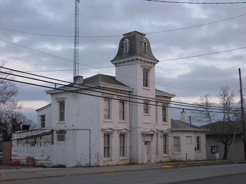
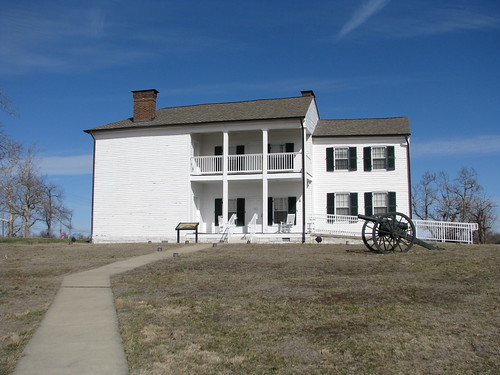
Big White House at Camp Nelson, Nicholasville, Ky.

Somehow, it was not until February 2011 that I visited Camp Nelson. A Jessamine County landmark, it is a well-spring of historical information and trivia. A Civil War-era camp established to supply Union troops, it also served during that war as a recruitment center for African-American troops and as a military hospital. Of the 4,000 acres once within its bounds, 400 acres have been preserved. It is also now the home of the Camp Nelson National Cemetery.

I could, and eventually plan to, write a number of posts about the rich history surrounding Camp Nelson, but I’ll begin with its most notable landmark that is locally known simply as the “White House.” Formally, it is the Oliver Perry House and was used as quarters for the officers. The only building remaining from the Civil War era, it is a two-story frame Greek Revival originally constructed by Oliver and Fannie (Scott) Perry circa 1850. During the War, the Union added the rear two-bay deep addition. The building had fallen under complete disrepair prior to its meticulous restoration by the Jessamine County Fiscal Court which has been an instrumental force in preserving this historic area.

In 1863, General Ambrose Burnside (for whom the sideburn is named – check out these chops) commandeered the Perry-Scott House and it was utilized by the Union for two years. Surrounding landowners also had their lands confiscated by the Union army to amass and secure the 4,000 acre site. The largest landowner was Mary Scott, Fannie Scott-Perry’s mother.

walkLEX: Nick Ryan’s Saloon

Lexington's Historic Western Suburb     Lexington's Historic Western Suburb
Empty Lot on Jefferson Street (before)     Nick Ryan’s Saloon (after)

The dining scene on Jefferson Street in downtown Lexington has been rapidly changing over the past couple years. Most of the changes have been positive (a sad note was when the Cuppa tea cafe closed earlier this month – obituary by thebravetart). One of the most positive improvements to this part of the Western Suburb is the construction and opening of Nick Ryan’s Saloon (where they proudly display the history of this great name).

As you can see from the pictures above, just a short while ago an empty lot sat on Jefferson Street across from the Harrison Elementary playground. A quick glance at the building wouldn’t reveal a building completed in 2010 — it looks like a much older building that has been well taken care of. The two story brick is patterned after the nearby Green Lantern with its long porches across the front and French doors which provide access to the open dining area. [*] Plans to renovate the neighboring building and expand were altered when it was determined that the structure couldn’t be saved; Nick Ryan’s will expand in yet another neo-historic building. [*]

But I’m not here to do a restaurant review (disclosure: I love the place). I’m here to appreciate how the restaurant embraces its pseudo-history. Recognizing that this is not a continuation of the old, Nick Ryan’s is an example of an excellent infill project for the primarily-residential neighborhoods that surround downtown. Aside from building a terrific building that is appropriate for the area, the owners selected a name with a Lexington history.

Nick Ryan’s Saloon existed before, circa 1905 on North Mill Street (at 120 North Mill, to be exact). Nick Ryan’s honors the tradition with historic photographs in the restaurant and on the website, though a love history is the only connection between the now and then. Of course, the real Nick Ryan who opened the original saloon in 1905 grew up in the Western Suburb where the new namesake saloon now resides. All saloons shuttered when prohibition began in 1920, but the Ryan’s survived with their other business interests (clothing and restaurants).
Nick Ryan's Saloon on Urbanspoon

NoD: Simon Kenton Bridge

Maysville, KY
Simon Kenton Bridge; Maysville, Ky.

The Simon Kenton Bridge spans the Ohio River between Maysville, Ky. and Aberdeen, Ohio (the picture above was actually taken in Aberdeen). The bridge opened on Thanksgiving Eve, 1931. Until that time, ferries were used (photo) to transport people across the Ohio (vehicular traffic had to go through either Newport, Ky. to the west or Portsmouth, Ohio to the east).

The first ferry authorized in Maysville (f/k/a Limestone) was in 1794 to Benjamin Sutton for whom Maysville’s Sutton Street is named after. But with the completion of the Simon Kenton Bridge, the ferries came to an end.

You may recall that Limestone was once part of Bourbon County and leaders from this region, including the namesake of this bridge (Simon Kenton), traveled to Paris to conduct county business. In 1777, Kenton saved the life of Daniel Boone and Kenton County is named after him. Born in Virginia and making his mark in Kentucky, Kenton ultimately settled and died in Ohio.

When this silver-painted suspension bridge opened, 15,000 people turned out. Four high school bands and the University of Kentucky Marching Band all performed to celebrate the opening of the 3,163 foot bridge. [*] Designed by a Harrisburg, Penn. firm, the superstructure was completed by the famous J.A. Roebling Company which had years before designed the Roebling Bridge in Covington (as a design model for its more famous Brooklyn Bridge). In 1945, the tolls were removed and the bridge became toll-free.

WalkLEX: Boss Klair’s House

Lexington's Historic Western Suburb
The Billy Klair House, Lexington, Ky.

We all recognize the name of Boss Tweed – the leader of the nineteenth century NYC political machine. A similar figure existed in Lexington in the early twentieth century: Billy Klair. His home, at the corner of Old Georgetown and West Short, is pictured above and is a landmark of the Historic Western Suburb.

Klair, in the words of Gov. Happy Chandler, “absolutely controlled Lexington.” He was known by all as “Billy” and he routinely apologized for “being sober,” helping to connect him to every voter. He served in the state Democratic Party organization and also served in the General Assembly.
In utilizing patronage, Klair ensured that a disproportionate number of Lexingtonians remained on the state payroll. His precinct organizational skills were impeccable — he even housed a “Sunday School” in his office with  friends on the police force during which they got together and informed Klair about what was going on around town. 
In business, Klair had his hand (and connections) in a number of businesses: saloons, hotels, book publishing and banks. His book publishing company produced nearly all of the state’s textbooks; critics said that if he were to publish a dictionary it could stop at “G” for “graft.” Despite lucrative textbooks contracts, Klair’s most successful venture was the insurance company of which he was a member: Klair & Scott Insurance. 
Despite the fact that neither Tom Scott nor Billy Klair knew anything about the insurance business, it quickly became one of the state’s biggest insurers. From his office on the sixth floor of the Security Trust Building, Klair insured the assets of the Commonwealth, the University of Kentucky, and Keeneland. Charlie Wiley, who would later become Lexington’s mayor described Klair as a “shrewd politician” and quipped that he had “fire and theft insurance on every bridge in the state.” Think about that.
Most of the information in this post comes from Bossism and Reform in a Southern City: Lexington, Kentucky, 1880-1940 by James Duane Bolin. 

NoD: Old Bath County Jail

IMG_5347
Old Bath County Jail, Owingsville, Ky.

OK. So this place doesn’t look like a jail, but I was told by the local historian on my visit to Owingsville that this was in fact the old Bath County Jail. And Google marks the location as the current “Bath County Jail.”

After a little internet searching, I can’t seem to find much on the building. A challenge to you all!? Help me find out more about this building, which looks like it was designed with (or to mirror) the Bath County Courthouse.

NoD: Justice Stanley Reed

Maysville, KY
Stanley Reed Ct., Maysville, Ky.

On New Years Eve in 1884, Justice Stanley Forman Reed was born in Minerva, Kentucky. Minerva, situated in Mason County, is a small hamlet – but the county seat of Maysville has not forgotten its native son. A plaque honors Reed at the old courthouse and the road adjacent to it bears his name.

Reed was appointed to the U.S. Supreme Court in 1938 after having served as Roosevelt’s Solicitor General. When he stepped down from the bench in 1957, he was the last Justice who had not obtained a law degree. Reed had previously obtained two bachelors degrees (Kentucky Wesleyan in 1902; Yale University in 1906) and had studied law, but not graduating, at both University of Virginia and Columbia University.

On the bench, Reed was the fifth “swing justice.” He was considered a progressive on economic and some social issues, but was decidedly more conservative on matters of free speech and national security. He is interred at the Maysville Cemetery and his papers are at the University of Kentucky.

“The United States is a constitutional democracy. Its organic law grants to all citizens a right to participate in the choice of elected officials without restriction by any state because of race.” – Smith v. Allwright, 321 U.S. 649 (1944).

NoD: Raceland’s Track

IMG_5278
Raceland Race Track Historic Marker, Raceland, Ky.

The town of Chinnville changed its name in 1924 when its greatest tenant arrived: a horse track. renamed  Raceland after the new track. Raceland, the track, hosted its first race, the “Ashland Stakes,” on July 10, 1924 before a crowd of 10,000. A few days later, a crowd of 27,000 witnessed the inaugural Raceland Derby, which featured five Kentucky Derby contenders including its victor Black Gold.

The one-mile oval track, nicknamed the “Million Dollar Oval” was apparently quite splendid. The track was surrounded by a white picket fence covered in “rambling red roses. The bridle paths and front lawn were paved in red tapestry brick, matching the clubhouse, steward’s stand and judges stand. The infield contained a alke and several sunken gardens.” [*]

Of course, it should come as no surprise to Lexingtonians that Raceland’s course was a beautiful racing venue. It was founded by Jack Keene who would go on to found his namesake racecourse, Keeneland, eleven years later.

Raceland, however, did not fare so well. Due to a lack of funds, the course closed in 1928 after only four seasons. Today, very little remains but a historic marker marks the spot. And so does a golf driving range.

NoD: Camp Swigert

IMG_5279
Camp Swigert historic marker, Wurtland, Ky.

It has come to my attention that some of you are disappointed when they see a pictured historic marker. Sure, a marker isn’t as attention-grabbing as something that still exists – but it does mark an important piece of history for a reason. Regarding Camp Swigert, Kentucky historic marker #2247 reads:

Union Civil War training camp was organized Dec. 12, 1861. Made up of 20-25 acres. It became center of volunteer enlistees under command of Col. D. W. Lindsey. Recruits from surrounding counties, Frankfort & Louisville were assigned to form the 22nd Regt of Ky Volunteer Inf. Both black and white infantrymen stationed at Camp Swigert.
Engaged in skirmishes in eastern Ky & West Va., followed by Middle Creek, Ky and Cumberland Gap,Tn. They moved through Tennessee and Mississippi. The 22 Ky Volunteer Inf. Regt. consolidated at Baton Rouge, La in March 1864 into the 7 Ky Veteran Inf. Non-veterans were mustered out in Louisville on January 20, 1865.

After the Battle of Chickasaw Bayou, the colors of the KY 22nd Regt was said to be both “torn” and “covered with blood.” [*]

Streetscape Project Threatens Local Businesses Again

Downtown Nicholasville
Main Street, Nicholasville, Ky.

This post was originally published yesterday on ProgressLex.

Lexington’s South Limestone Street is truly beautiful. The work done to revitalize that gateway into downtown Lexington put the utilities underground, improved the sidewalks and streetscape and completed some necessary underground storm sewer work. But the improvements came at a great cost as many locally-owned businesses struggled to survive (some failed) during a construction process that lasted much longer than projected.

I am confident that Nicholasville’s Main Street will be equally as beautiful once its streetscape project is complete. But in a small town without a college next door, it may take longer for the local businesses affected by the construction to rebound.

The project engineers, CDP Engineers, originally suggested that construction would be coordinated to “minimize the overall effect to the downtown businesses unlike … the S. Limestone Project in Lexington where the entire street will be closed for up to a year.” Now, six months after work began, the project is less than 50% complete.

At a meeting on March 21, a representative from CDP Engineers reminded those gathered at a public informational meeting that the stated goal of the revitalization project was to bring “urban life [to] downtown Nicholasville.” One of downtown Nicholasville’s finest “urban” assets was the Main & Maple Coffee Shop – a community gathering place, that closed its doors on March 18. Other businesses have shuttered as a result, at least in part, due to the ongoing construction.

But in Nicholasville, gems remain. The Alternative Jewelry Shop creates beautiful, one-of-a-kind fine jewelry. Euro is a tapas bar which turns out excellent tastes and even more excellent drinks. These locally-owned businesses (and others) have survived the first six months of construction only to face a still-uncertain construction timetable.

Remember supporting the South Limestone businesses when they faced a similar situation? Now is the time to come to Nicholasville and support its fantastic locally-owned businesses.

NoD: Bridges of Camp Nelson

Camp Nelson
Camp Nelson Bridge, Jessamine/Garrard county line, Ky.

Pictured above are the three bridges, or at least what remains of them, which crossed the Kentucky River from Jessamine into Garrard County. In the upper-left you can see the current Camp Nelson Bridge which carries US-27 high above the river. In the middle remains the southern stone approach from the double-barreled covered bridge that spanned the site for nearly 100 years (1838-1933). The steel-truss structure from which this picture was taken remains, but is closed to traffic; it was open from 1933 until 1971.

More on each of these three bridges to come…