walkLEX: Western Suburb

Lexington's Historic Western Suburb
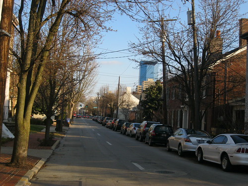
West Short Street in the Historic Western Suburb, Lexington, Ky.

On the most recent deTour by the Bluegrass Trust, we visited the Historic Western Suburb. Having grown up in this neighborhood, I was quite familiar with some of the stories – but there is always more to learn. Short Street, the 600 block of which is pictured, is the focus of the neighborhood which stretches from Newtown Pike to Saunier Avenue with a number of jagged north-south variations (see this map) to encompass historic properties.

The neighborhood was formally platted in 1815 making it one of (if not the) oldest suburb of Lexington.  The land – and much of the area – had been owned by Colonel John Todd, a Revolutionary War officer who was killed at the Battle of Blue Licks. His daughter, Mary Owen (aka Polly), inherited all of her father’s vast estate making her the richest woman in Kentucky; she was three years old.

Greek Revival architecture is predominant in the HWS is Greek Revival, but architectural style is as diverse in the WS as the people who have called her home. Throughout its history, the neighborhood would be considered what is now “upper middle class.”  Lawyers, businessmen and others have always called the HWS home. Their businesses were often located next to the businesses, leaving opportunity for later infill.

One of the HWS most notorious residents was the famed Madame Belle Brezing. She learned and practiced her trade in neighborhood brothels (one of which was located in what is now the Mary Todd Lincoln House). Apparently, Madame Brezing’s first participation in the sex trade occurred at the lumber yard which was located at the site of the gas station (Main and Old Georgetown).

This post was republished by kyforward.com on May 6, 2011.

NoD: Hayswood Hospital

Atop the hill overlooking Maysville and the Ohio River rests the old HayswoodHospital. A massive and imposing structure that by all accounts is quite haunted, the old hospital has been an empty shell since 1983. As a result of almost thirty years of abandonment, it looks like something right out of the History Channel’s Life After People.


Built in 1915 (expanded in 1925 and 1971) atop the demolished remains of the even older Wilson Infirmary (which dated to the 1800s), the hospital closed with a patient capacity of 87 beds. Since its 1983 closure, a number of different ideas have been levied of what to do with the property – but currently only time and invasive species have bothered to invest.

The ghost stories are many and are well-documented (from AbandonedOnline.net):

According to several accounts, a woman carrying a baby was seen walking through the nursery area of the hospital. The woman, having died in labor, was soon followed by the newborn (4). Others have reported seeing doctors in the hallways and hearing the cries of its former patients, along with spotting lights in the windows. And the few have reported seeing strange markings in the basement that bestow a threatening hostility on whoever walks or drives by.

I would have ventured deeper into old Hayswood, but I was alone and had concerns about the buildings structural soundness. The pictures are so cool, I’ve embedded a slideshow and have included lots of links (most of which have even more awesome pictures).

NoD: Alanant-O-Wamiowee

Maysville, KY
Historic Marker #84; Maysville, Ky.

Kentucky Historic Marker #84 states that

Ancient buffalo trace carved in the wilderness by prehistoric animals seeking salt. Trace was later used by buffaloes, mound builders, Indians and pioneer settlers. Also known as Warrior’s Trace.

There are a couple of conflicting reports regarding the path of this particular trace. The historic marker, as well as Filson’s 1784 map, identify this trace as the “Warrior’s Trace” which generally heads south from Limestone n/k/a Maysville southeast before cutting through the Cumberland Gap; this is likely correct. But there are other sources, including the Kentucky Encyclopedia, labeling the Alanant-O-Wamiowee as the which have it going through what is now Big Bone Lick and crossing the Kentucky River near Leestown. This buffalo trace is located near and lends its name to what is now the Buffalo Trace Distillery. A third trace nearly paralleled the first until it reached the Blue Licks to turn southwest toward Lexington.

Regardless of the course, these traces were wide swathes of land cut into forest and leaving permanent paths where the large bison (and their now-extinct sister-species) would migrate. The paths were later used by armies and settlers, and more recently as road beds.

NoD: St. Patrick’s Parish

St. Patrick Catholic Church - Maysville, KY
St. Patrick Catholic Church; Maysville, Ky.

One of the first buildings I noticed in Maysville was the Catholic church. An impressive contemporary interpretation of the Romanesque style, St. Patrick’s Parish includes many Gothic qualities in its brick and stone construction. [*] In April 1901, Fr. Patrick M. Jones became the parish priest and found the parish and its buildings in poor condition. The existing parish church was all-brick and had been erected in 1849.

Fr. Jones had been born in County Limerick, Ireland in 1853 and emigrated to the United States in 1875. Ordained in the Covington Diocese in 1877, he ultimately came to his pastorate in Maysville. He worked tirelessly to grow the parish and to improve its buildings. On June 26, 1910, the present church was dedicated. It seats 1,200. The considerable sum raised for the church’s construction was $100,000; the church was built (as well as a school, cemetery expansion and so much more) in a rather quick period of time. To note, all this was done with little debt:

[*] It is a great testimony as to how the St. Patrick’s Parish grew. As I’ve found with Catholic churches, St. Patrick’s was open on a typical day for prayer and reflection. The altar is beautiful; check out my other flickr photos.

NoD: Don Gullett Country

IMG_5298
Don Gullett Country Memorial; Greenup, Ky.

On the lawn of the Greenup County is a memorial declaring that “This is Don Gullett Country.” I’ll be the first to admit, I didn’t recognize the name. I recognized the subject of he neighboring memorial, for Jesse Stuart, plus the Stuart memorial offered details as to who Stuart was.

I had to rely on Google to learn about Don Gullett, and I suppose if I were more of a baseball fan I might have recognized the name. Gullett was born in South Shore (Greenup County), Kentucky in 1951. Before he could drive, pro and college recruiters – baseball, football and basketball – were coming to Greenup County to watch him play at McKell High School. He skipped college and was drafted by the Cincinnati Reds in 1969. He played for the Reds for a few seasons before being picked up as a free agent by the New York Yankees.

During his pitching career, he won four consecutive World Series (1975, 1976 with the Reds; 1977, 1978 with the Yankees). His stats are available here. Gullett, suffering from shoulder injuries, retired from the game in 1979 and was released from the Yankees in 1980. He is enjoying retirement on a farm near his birthplace in South Shore.

NoD: Birthplace of General John Bell Hood

IMG_5324
Birthplace of Gen. Hood, Owingsville, Ky.

General John Bell Hood was born in Owingsville, Kentucky in June, 1831. He served the Confederacy in the Civil War and did so with one of the most awesome beards in history. At Gettysburg, Hood (either by confusion or derelection) made a blunder which cost him the use of his arm. It also, arguably, cost the South a victory at Gettysburg and (given that the battle was the turning point of the War) the War. Am I exagerating history a little? Possibly.

We’ve highlighted this house before on the Kentucky120 visit to Owingsville, but inaccurately suggested that Hood was born in the house pictured; to clarify, he was born in a home that previously occupied the site. Yes, there is something about John Bell Hood that exudes hyperbole and exaggeration.

walkLEX: Behold, Lexington (part deux)

Architect’s rendering of the proposed development. [*]

In April 2010, I posted about the announced project to built a CVS drugstore at the eastern entrance to downtown (across Main Street from Thoroughbred Park). The block, which I then pictured in its state of demolition, had consisted of mostly surface parking and single-story commercial buildings. The proposal to build the CVS was soon met with great opposition by a community action group, ProgressLex, which argued against the design of the CVS as being inappropriate for its position as a gateway into the downtown area. As a result of ProgressLex’s efforts, CVS slowed development to consider community input.

Construction was to begin in September of 2010, but the discovery of an underground utility box further delayed construction. Today we get word that a three-story mixed use development will be built at the location. Architectural renderings indicate a structure with a design similar to that of the modern Main+Rose, yet a small green area (with public art?) will be left for the easternmost (and prominent) corner. And a parking structure is proposed as well, eliminating the debate (for this site) about the overabundance of surface lots which reduce Lexington’s urban density.

I’ll look forward to seeing more information about this development, though I remain concerned about the introduction of two floors of office space when we already have a significant amount of vacant commercial square footage throughout Lexington (including downtown).

NoD: Margaret Garner (Kentucky Chautaqua)

The Bluegrass Trust hosts a monthly brown bag lunch lecture series at the John Hunt Morgan House. In celebration of Black History Month, this month’s event was held at the Downtown Arts Center and was a live one-person Kentucky Chataqua show from the Kentucky Humanities Council

The Modern Medea, by Thomas Satterwhite Noble

Margaret Garner was a slave born in Boone County, Kentucky. Light-skinned, she was likely the daughter of her master – John P. Gaines (who was appointed by Pres. Zachary Taylor to be the governor of the Oregon Territory). When Gaines left her Oregon, he sold his farm, Maplewood (to which this post is geotagged), to his brother Archibald Gaines.

Archibald was a cruel master and ultimately, Margaret sought to escape with her three children. In the snowy winter of 1856, she escaped and crossed the frozen Ohio River, but was ultimately captured. Before her capture, however, she slit the throat of one of her children (she was stopped before she could kill the others) because she believed her children would be better in heaven than back in slavery. According to the story, Archibald was the father of each of her children and she didn’t want her daughters to be assaulted by their white masters.

Tried in Covington (rather than in Ohio), Garner was returned to slavery and sold down the river. The story of Margaret Garner was immediately well-known as it was publicized by both abolitionists (decrying the pathology of slavery) and pro-slavery forces (claiming that slaves were all subhuman). [*] The painting above, The Modern Medea, by Thomas Satterwhite Noble was inspired by Garner and was painted in 1867.  Her story was popularized again by Toni Morrison’s book, Beloved. Former UK professor research Garner, writing Modern Madea. There is also an opera about Garner which can be heard on NPR.