Along the Great Allegheny Passage: Ohiopyle

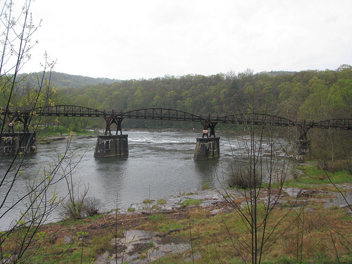
Ohiopyle Low Bridge Spanning the Youghiogheny River

Ohiopyle, Pennsylvania had as of the 2010 population a permanent population of 59. This small borough, however, comes alive during the summer months. Arriving in April, we beat the summer rush of adventure seekers on the rapids of the Youghiogheny River.

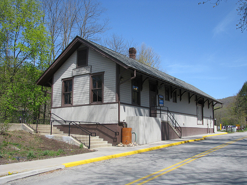
Restored Ohiopyle Rail Depot

Ohiopyle is also a trail town along the Great Allegheny Passage, a rail-trail linking Cumberland, Md. to Pittsburgh, Pa. Ohiopyle was also our starting point for our first venture on the GAP which would take us along the route of the old rail lines of the Baltimore and Ohio Railroad, Pittsburgh and Lake Erie Railroad, Union Railroad, and the Western Maryland Railroad. Our journey would extend from Ohiopyle to Frostburg, Md. and back.

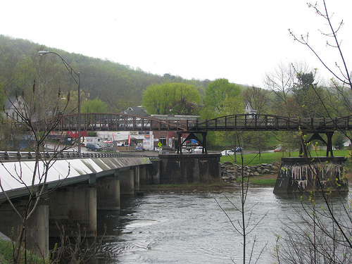
Ohiopyle and the Low Bridge

We arrived in Ohiopyle later than expected, but early enough to get a bite to eat before beginning our day’s trek to Meyersdale, Pa. A tasty lunch at the Ohiopyle Bakery & Sandwich Shoppe was both tasty and filling. The bakery/cafe opened in 2011 and is one of many eateries in this community – a testament to the tourism brought to this trail town of 59!

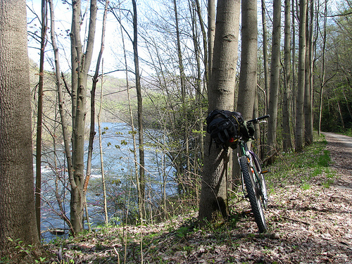
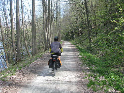
The Yak and the Trail

Our first 11 miles of trail, between Ohiopyle and Confluence, are five-star rated by National Geographic. They write, “The beauty of the Southern Ohiopyle section of the trail rivals that of the Northern section. Rapids abound and there are plenty of places to leave the trail and find your way down to the rivers edge.”

One cannot overstate how gorgeous this part of the ride was; the rapids of the Yak River and the just-beginning-to-bloom flora around the trail were simply picturesque.

There is also history along the trail. The occasional marker recalls the mills and pioneers that once settled this wilderness. Maple syrup, rye whiskey, grist and saw mills were all trades undertaken by these early settlers.

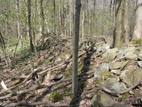
Dry laid stone wall along the GAP

Little is remaining from the earliest settlers, but a marker near a dry-laid stone wall recalled these early Scots-Irish and German pioneers. Looking carefully, one can also spot what would have been the channels diverting water to and from the mills in the area.

This is the first part of a multi-part series on the Great Allegheny Passage. The next segment will be about the community of Confluence, Pa. The remainder of my photos from the GAP Trip are available on flickr.

Kentucky’s Reputation Hurt by de Tocqueville’s Missed Opportunity

Chaumiere’s “octagon room” asserted to have been built
for Gen’l Lafayette, who never visited
Photo: Jess. Historical Society
Alexis de Tocqueville

On Dec. 5, 1831, the Ohio River froze over, making voyage impassable for Alexis de Tocqueville and his party. They disembarked at Westport, Oldham Co., Ky. and walked the cold 22 miles to Louisville. It was one of many poor experiences that during a 10-month voyage planned to determine “what a great republic is like.”

Upon reaching Louisville, the river still offered no passage and de Tocqueville experienced a large swatch of central Kentucky as he traveled south toward Nashville. His writings on Kentucky were not kind:

“Nothing in Kentucky … gives the impression of such a finished society.”

Kentuckians “are well known through the union for their violent habits.” “They seem to deserve that reputation.”

Ouch.

Though unimpressed with Kentucky, de Tocqueville extolled the United States in his great work, Democracy in America. In this magnum opus, he warned that “when the past no longer illuminates the future, the spirit walks in darkness.”

To avoid such darkness, we should take occasion to examine our history. A great starting point in the history of Jessamine County is the grand country estate of Colonel David Meade: Chaumiere des Praries.

A young David Meade
Photo: Rootsweb

Colonel Meade was born in Virginia, schooled in England and married a young girl from Williamsburg, Va.

He served in the House of Burgesses which was dissolved by Lord Botetourt, the then-governor of colonial Virginia. He would not again hold public office. Instead Colonel Meade acquired a significant estate on the James River. It is said that here “he practiced the fine art of landscape architecture and hospitality, and often entertained the leaders of Virginia.”

In 1796, however, Meade departed Virginia for the wilderness of Kentucky.

The year before, he had purchased about 300 acres in what is now Jessamine County. Once here, he would master that fine art of landscape architecture with his Chaumiere des Praries.

Of Chaumiere’s landscape, Meade’s granddaughter wrote: “The grounds were extensive and beautiful; at that time it was said there was not so highly and tastefully improved country seat in America. … And then the walks — the serpentine one mile around … and in a secluded nook, a tasteful Chinese pavilion. The birdcage walk was cut through a dense plum thicket, excluding the sun, and led to a dell, where was a large spring of water, and the mouth of a cave.

At this point was the terminus of the lake, and … a waterfall.”

His house guests were both frequent and notable: James Monroe, Andrew Jackson, General Charles Scott, and Zachary Taylor were all guests. Statesman Henry Clay and Transylvania University president Dr. Horace Holley were both known to regularly travel 9 miles from Lexington to the house and gardens at what is now Catnip Hill Road.

Nothing but glowing remarks of Col. Meade’s hospitality, his home, and the grounds of Chaumiere have been written. Dr. Holley wrote that “there is no establishment like this in our country.”

Chaumiere des Praries was a site to behold. Meade died in 1832 (the year after de Tocqueville traversed Kentucky); the estate sold in 1835 to a “plain practical farmer” who quickly turned the Colonel’s gardens into grazing pastures. The farmer felled trees, destroyed the parks and drained the lakes.

Neighbors, incensed, decried the “Paradise Lost.”

But how different would de Tocqueville’s impressions of Kentucky have been had he feasted at Chaumiere and strolled its grounds?

This text for this post originally appeared in the Jessamine Journal. It should not be republished without permission.

Louisville’s Most Endangered Properties

Preservation Louisville has released the names of the community’s most endangered historic properties.

  • Vacant & Abandoned Shotgun Houses, which are in dwindling supply in the city
  • Colonial Gardens, described as a “dilapidated reminder of the South End’s colorful past, historic value and uncertain future.”
  • Mid-century modern structures are not old enough to be recognized by enough people for their signficance and too few steps are being taken to preserve the era’s architecture
  • Ouerbacker House, 1633 W. Jefferson Street, ca. 1860-1865.
  • Corner store fronts of retail establishments from antebellum to midcentury were staples of American life as we shopped in the local general store. 
  • Roscoe Goose house, 3012 S. Third St., ca. 1900, was occupied by the jockey who rode 91-1 Donerail to victory in the 1913 Kentucky Derby.
  • Lampton Baptist Church, located at 850 S. Fourth Street, was founded in 1866.
  • Doerhorfer house, 422 W. Broadway, was designated a city landmark in 2011. Despite the designation, the 2 1/2 story frame structure remains at risk.
  • Historic Old Clarksville Site in Indiana is where George Rogers Clark built his cabin and mill. It is a key part of Kentuckiana history and must be protected for future generations.
  • Water Co. Block downtown Louisville contains many older structures utilized by the old water company. A mixed use development proposal puts them at risk.

This Just Happened, a weekly roundup (Happy Mother’s Day Edition)

My Mom walking the ‘Lil Kaintuckeean down
a Lexington sidewalk a couple years ago

Happy Mother’s Day to all the Kentucky moms and grandmoms out there!

To celebrate, the Louisville Slugger is going pink! [Courier-Journal]

It apepars that a superb series of television programs on Kentucky’s rich history will air on KET in the coming weeks. [KYForward]

In the words of Yoda, revisiting its alcohol-free campus policy UK may be. [LEX18]

Kentucky’s first trail town is Dawson Springs in western Ky. Can’t wait to visit [14News]

Plans for recovery for tornado-ravaged West Liberty [Herald-Leader/Tom Eblen]

A Franklin County farmhouse built around the original log-cabin saddlebag is undergoing the NRHP application process [LEX18]

… And From Elsewhere …

Abandoned Chicago landmarks Cook County Hospital and Brach’s Candy Factory face an uncertain future [WGN]

Philadelphia’s Woodlands is the scene for a new movie directed as a thesis project by a Temple U student [Bricks+Mortar]

An Update from the Garden

How does your garden grow?

The last time I wrote of my garden I was scouring through seed packets deciding and deciding on plantings. Now the raised beds are constructed after a long winter of caring for seedlings under indoor grow lights.
Through the use of the po’ man’s greenhouse (PVC piping and plastic sheeting), I was able to get a head start on lettuces, radishes, beets, collards, and carrots – some of which is ready for the tasting this Mother’s Day weekend.

Indoor Grow Light Setup at the Beginning

The seedlings under grow lights in the basement are ready to come forth, though a light frost anticipated for early next week may keep them nestled away a few more days.

This weekend should (fingers crossed) allow time for some final planting. So far, I’ve got plants in four of the five raised beds and many more of the outdoor seeds should be sewn over the weekend.
Hopefully, I won’t be so derelict in future garden updates. But more importantly, I shan’t ignore the garden. The sugar snap pea trellis was not in place until this morning – climb, oh sweet pea! Climb! 
Until next time.

Celebrate National Bike Month and Cycle to Work

The following column of mine appeared in the Jessamine Journal on May 8, 2013:

May is National Bike Month. Sponsored by the League of American Cyclists, National Bike Month celebrates “the unique power of the bicycle and the many reasons we ride.” The idea is to encourage cycling for commuting to work or to school. Doing so can save money and is healthy for both your body and for the environment. Plus, it is a great way to explore the community that you might miss from the inside of a car. 

Next week, May 13-17, is Bike to Work Week during which those with bicycles are encouraged to bike to work. You don’t have to ride every day, and even cycling to work one day will have a positive impact. If you can only ride one day, May 17 is designated as Bike to Work Day. (But try to ride any day it works into your schedule). 

For me, I’ll trek the estimated 20 miles from my house to my office in downtown Lexington as many days as possible. I can comfortably ride the distance in just under 90 minutes accounting for traffic along the way. 

Without a doubt, US 68 – with the paved mixed-use path parallel to the highway — is by far the easiest and best route to take. The Kentucky Transportation Cabinet and all involved in planning that mixed-use route deserve accolades and should attempt to create similar conditions as other road projects are planned. 

But your route is likely different than mine. 

The rest of my column can be found at the Jessamine Journal’s website. Click here.

In Kentucky, Four Additions to the National Register and Two Newly Designated National Historic Landmarks

Each week, the National Park Service transmits a list of properties added to the the National Register of Historic Places. Depending on applications pending, there are weeks where no Kentucky properties are listed for inclusion. Some emails are full of Kentucky’s rich history. Such was a recent e-mail.

As I alluded to in one of my weekly roundup’s last month, two Kentucky properties were designated as National Historic Landmarks. This designation is the highest designation that can be afforded a property in terms of historic significance. With the inclusion of the George T. Stagg Distillery in Franklin County and the Camp Nelson Historic and Archeological District in Jessamine County, the number of Kentucky properties designated as National Historic Landmarks rests at thirty-two.

North elevation of the Liggett and Meyers Harping
Tobacco Storage Warehouse, Source: NRHP App./KHC

From Lexington, the Liggett and Meyers Harpring Tobacco Storage Warehouse (1211 Manchester Street) was added to the Register. Constructed in 1930, the warehouse sits on a six acre tract and was well-situated to tobacco storage. A rail spur from the L&N railroad ran to the property and, as preferred shipping methods changed, proximity to New Circle Road kept the Liggett and Meyers building relevant. The building itself is constructed in six segments with each segment containing 20,000 square feet. This immense structure was important to an industry vital to central Kentucky. Today, the building is part of the city’s growing Distillery District.

Ludlow Theatre, ca. 1975
Source: NRHP Application / KHC

The Ludlow Theatre, 322-326 Elm Street, is in the community of Ludlow in Kenton County. The Ludlow Historic District, added to the National Register in 1984, already includes the ca. 1946 theater, but the Ludlow Theatre is now individually listed. Of course, in 1984 the Ludlow Theatre (then less than 50 years of age) was deemed a non-contributing structure, yet the passage of thirty years has changed perspective. Consistent with much of the architecture built in the mid-twentieth century, the Ludlow Theatre is “largely a modest modern building
with little to characterize it within a specific style.” Architectural interest is found in the façade, however, as every sixth of the variegated brick projects slightly from the façade. The most significant change to the building’s exterior since 1946 is the removal of the marquee. This occurred around the time of the historic district’s inclusion on the Register, but can be more readily attributed to the theatre’s closure in 1983.

Hindman Historic District
Source: NRHP Application/ KHC

As Nate wrote, “There is no legitimate reason why anyone would ever stumble upon Hindman.” Though, remarkably, the National Register application remarks that “few Kentucky counties can match the education, literary, cultural, and political heritage found in and near Hindman.” With credits like that, one can imagine the variety of architectural styles found in the district. Much can be credited with three of the earliest Appalachian Settlement Schools being established in Knott County. So if one were to stumble into Knott County’s seat, they would find the sixty-one buildings in the Hindman Historic District, of which 40 are deemed to be contributing. They consist of religious, governmental, residential, commercial, educational, and health care purposed structures, though the majority are two-story residences and commercial structures built between 1903 and 1960. After this period, however, many older structures have been significantly altered or demolished and this has diminished the historic character of the community.


Buck Creek Rosenwald School
Source: Kentucky Heritage Council

Finally, the Buck Creek Rosenwald School in Finchville was constructed ca. 1920 as a one-room school house and was adapted into a residence in 1959 (the school had closed in 1957). One story with hipped roof, this simple structure was a Rosenwald school for African American children during the years of segregation. It was one of only two Rosenwald schools in Shelby County. Two contributing buildings – an outhouse for either sex – are also mentioned in the National Register application. The application also contains accounts of the school day from former students – a fascinating read! More fascinating is that the application was the project of Girl Scout Julia Bache in pursuit of her Girl Scout Gold Award. Well done, Julia!

A Slideshow from the Great Allegheny Passage

Me riding the GAP Trail between Ohiopyle and Connellsville, Pa. 

Last weekend, my brother and I rode our bikes on the Great Allegheny Passage – a rail-trail from Pittsburgh, Pa. to Cumberland, Md. Our ride covered 133 miles from Ohiopyle, Pa. to Cumberland, Md. and back.

It was an incredible journey full of history and natural beauty. I’ll post more on this trip later, but wanted to go ahead and share with you the photos.

If you don’t want to look at the pictures through the slideshow, you can view the flickr set here.

A Map Received with Gratitude: 1873 Colton Map is Unique

Colton’s Map of Kentucky (1873)

At least one colleague and friend discovered my interest in history through last week’s Herald-Leader article by Cheryl Truman. To my luck, the avid baseball fan and history buff had an 1873 map of Kentucky which he has graciously given to me. It originally belonged to his grandparents, and he knew I would appreciate it.

The 1873 map was published by G.W. and C.B. Colton & Co. of No. 172 William St., New York. I’ve reached out to noted New York bloggers and amateur historians, The Bowery Boys, to see what they knew about the cartographers or their locale in the early 1870s? So far, I got nothing. But a study of their website does reveal a picture from 1859 of William Street, which today runs from the foot of Brooklyn Bridge near Pace University downtown to Broad Street. 172 William, near the intersection with Beeker, is now predominated by Downtown Hospital. Here’s what it looked like a few years before the Coltons published by map from two blocks uptown:

NYC: William Street from Frankfort (via Bowery Boys)

I learned that J.H. Colton was an internationally recognized cartographer from 1831 to 1890. His two sons were brought into the fold in the early 1850s: George Woolworth Colton and Charles B. Colton.

G.W. and C.B. It looks like the two sons published the map which is seemingly unique. There are many Colton maps spanning multiple decades which combine Kentucky and Tennessee, but I’m not finding one of just Kentucky. Truly unique, at least per the University of Alabama’s historic map collection.

Do you have any information about this map?

This Just Happened, a weekly round up (Kentucky Derby 139 edition)

Yesterday in Louisville, Kentucky’s signature event – the fastest two minutes in sport – cofavorite Orb brought home the roses on a sloppy track [ESPN]

The Helix opens tomorrow in Lexington. No, it’s not a cool bar; it’s the parking garage next to the police department which has been undergoing costly but necessary repairs for months. [BizLex]

Evidence of cannibalism among America’s earliest settlers reports Smithsonian [TPM]

The sun shines bright on Lexington food trucks as steps are being taken to expand their footprint [Herald Leader]

A great photologue of Covington’s “front, back and side doors” with an eye toward improving entry to this northern Kentucky city [RiverCityNews]

Lexington’s Town Branch Commons had a huge public presentation last midweek. I missed it, but ProgressLex didn’t. Check out the video of the half-hour presentation! [ProgressLex]

Another thing I missed was the tour of the historic East End in Lexington – a hotbed of African-American history. Another tour is slated for June [Merlene Davis / H-L]