Uncertain Fate for 1914 Neo-Classical Home in Nicholasville, Kentucky

At an auction yesterday, a century-old home on the south side of Nicholasville was auctioned off. The property located at 1201 South Main Street was advertised as including over 32 acres ripe for development. So the question is will this circa 1914 home be standing in a year (or even a month)?

The answer to that question is unknown.

So what is at risk of being demolished?

This yellow brick two-and-one-half story Neo-Colonial was built in 1914 by Everett B. Hoover. When added to the National Register of Historic Places in 1977, the house was described as “one of very few examples in Jessamine County of early 20th century styles; it is also one of the best designed and well preserved examples of the Neo-Colonial style in the county.”

Mr. Hoover was the son of William H. Hoover who was the subject of a brief biography in Perrin and Kniffin’s 1887 Kentucky: A History of the State. Of Everett, the authors wrote:

Everett B. Hoover, the third and youngest child, was born October 21, 1860, and like his brother received his early education in the free
schools and at Bethel Academy; in 1877 he entered the Wesleyan College at Millersburg, Ky., where he remained until 1879; then entered Vanderbilt University, where he took a special course of study, preparatory to studying law. In 1880 he entered the Columbia College Law School, New York City, where he remained two years, taking the full law course, graduating in June, 1882. He at once returned to his home and received his license to practice law in August, 1882, and has been a continued practitioner ever since. He married Miss Ella Burnett, of Boyle County, Ky., November 21, 1882. To this union was born Elizabeth Hoover, the first grandchild of William H. Hoover, January 31, 1884. In April, 1886, Everett B. Hoover was elected judge of the city court of Nicholasville, Ky., and was re-elected the following year, of which office his is the present incumbent.

The house was last on the market in 1967 when it was purchased by Charles and Anna Moore. Prior to the Moore’s acquisition, the property served as a sanatorium operated by Charles Fentress.

Charles Moore was a developer in Lexington during the mid- to late- twentieth century. In reporting Moore’s death in 1985, the Lexington Herald-Leader wrote that “Moore built houses in many of Lexington’s major subdivisions and helped develop several shopping centers (ed. including Southland) over the years.” And in 1967, Moore purchased this house as part of a 222-acre farm and then did what he did best: developed the majority of land that sits approximately one mile from Nicholasville’s courthouse.

According to a history of the house written by Elexene Cox, the site was also the home to “an equally lovely home on land that was the subject of one of Jessamine’s earliest controversies.” She continued:

After John Metcalfe laid out the town on Sept. 16, 1798, he wrote later to High Sheriff Charles West: We have succeeded amid foolish opposition from County Clerk Samuel Woodson and County Surveyor Frederick Zimmerman in locating our county seat. Woodson wanted it near his residence one mile to the south and Zimmerman wanted it one mile to the north of my survey. We have defeated their opposition. … Woodson’s ‘gem of a house’ had 14-foot ceilings and a hall 12-feet wide.

It was this “gem of a house” that Hoover demolished (at a cost of $150 for “separating all the woodwork, cleaning and separating all the stone and brick in less than a month.”) in favor of the still-present construction.

According to Cox, Hoover hired David Wolfe of Georgetown to build the house which, with “extras,” cost $9,474.

At yesterdays auction, the house and land were purchased for $1,177,000. Hopefully, this historic structure can be incorporated into any new development that might occur on the property.

All images were obtained from marketing materials related to the auction of the property by Halfhill Auction Group. As of this posting, additional images of the property are accessible on that website.
UPDATE (11/3/16 at 4:00 p.m.): Communication with one of the purchasers suggest that there are “no immediate plans” for demolition. 

Comment on the Kentucky State Road Plan to put a Stake in the Vampire Road

Over the years, I’ve written several posts in opposition to the proposed I-75 Connector that would slice through Jessamine and Madison counties to connect Nicholasville with the interstate. The proposed road is expensive, wouldn’t add much time savings for travelers, would destroy natural landscapes and historic places, and is an all-around bad idea. 
In one post, I wrote about how the Economics of I-75 Connector Don’t Add Up. The proposed cost of this 13-mile road is about $400-500 million. All to build a new road while existing infrastructure needs critical repairs. In another post, Marble Creek is a Jessamine County Treasure, I observed that “once lost, natural and historic resources cannot be created.” There is too much to lose with the connector. 
Since I published these posts, I’ve gotten several inquiries on what people can do to stop the connector. How do we put a stake in the Vampire Road?

Projected paths of the I-75 Connector

A Call to Action

Well, now through August 15 you have the opportunity to do something. Next Monday, August 15, 2016, is the deadline for public comment on the State Transportation Improvement Plan, or STIP. STIP is a 3-year statewide list of transportation projects in the state. This period of public comment is intended to solicit the opinions of the people ofKentucky – so let your voice be heard!

Stand up against the I-75 Connector!
According to the STIP, $2 million is proposed to be expended in 2017 for design, $10 million in 2019 for right-of-way acquisition, and $3 million in 2020 for moving utilities. That’s real tax dollars going toward an unnecessary and expensive project that will negatively alter the future of Jessamine County.
Comments should be directed to Sherry Curry. Her email is [email protected]. Additional information about the Statewide Improvement Plan can be found by clicking here. In your email, be sure to reference your opposition specifically to “Item No. 7-8404 in Jessamine County.”

Take action and contact Ms. Curry with your opposition to Item No. 7-804, the I-75 Connector in Jessamine County.” 

5 in ’15: The Best of the Kaintuckeean in 2015

The majority of posts on this site focus on Lexington, Kentucky history and historic preservation. But looking back at 2015’s most popular posts on the Kaintuckeean revealed a couple of fascinating details. One big overservation was that 4 of the 5 most popular posts were about subjects outside of Fayette County. That’s because, well, “Kentucky Kicks Ass.”

And 2 were from Nicholasville! So read on and discover the posts. Last year, I included the page of my book, Lost Lexington, in the rankings. Though it would have been #3 this year, I opted to include only posts. But thanks for continuing to love the book!

#1: Graded School Ruins Along the Dawkins Trail

The Ivyton School in Magoffin County can be spotted from the junction of the Dawkins Trail and the Mountain Parkway.

Read More: Graded School Ruins Along the Dawkins Trail

#2: No Destination: Griffith Woods

Griffith Woods, in Harrison County, once had a tavern that was relocated to Clark County in recent years.

Read More: No Destination: Griffith Woods

#3: Lexington’s Newest Disappearing Neighborhood

The 1920s houses in this area were demolished in 2015 to make way for the new Shriner’s Hospital

Read More: Lexington’s Newest Disappearing Neighborhood

#4: Another Nicholasville House is Gone

Another house from the 1920s is lost to demolition. This one is in Nicholasville. 

Read More: Another Nicholasville House is Gone

#5: A Snow Covered Nicholasville

A foot of snow on the ground in Nicholasville resulted in some beautiful pictures. Hoping we don’t repeat this in 2016!

Read More: A Snow Covered Nicholasville

Yes, there were a lot of great posts in 2015 and I hope to share some more of Kentucky’s awesome and rich history, people, and places in 2016!

One final statistic, the three busiest days on the Kaintuckeean were Feb. 23 (A Snow Covered Nicholasville), March 11 (Lexington’s Newest Disappearing Neighborhood), and November 30 (Graded School Ruins Along the Dawkins Trail). Those dates brought in a lot of traffic with some popular posts!

Thanks for a great 2015 and I wish you and yours a happy and prosperous New Years! 

Another Nicholasville House is Gone

404 West Maple Street – Nicholasville, Ky. Jessamine County PVA

A month or so ago, my family was walking along Nicholasville’s West Maple Street when my wife commented on what appeared to be work being done at 404 West Maple Street. My heart jumped as I thought that this circa 1921 residence would be remodeled and given a new lease on life.

This, however, was not to be. On Black Friday (2015), the house was demolished. According to records of the property value administrator, the two-story house had 2,228 square feet. But the house would not reach its 95th year.

404 West Maple Street – Nicholasville, Ky. Author’s collection.

The house was acquired most recently by auction in September 2015; the photo above was taken post-auction. The stone foundation supported a frame structure encapsulated in aluminum siding amongst its many windows.

The Home of Hugh “Buddy” Adams

Headstone of Mr. Adams at
Camp Nelson. Judi Fryer.

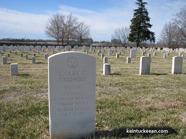
Its most noted owner was Hugh “Buddy” Adams, a former superintendent of Jessamine County Schools who retired in 1983. Buddy Adams was an alumnus of both Transylvania University and the University of Kentucky. He served in the U.S. Army Air Forces as a Staff Sergeant during World War II and was a deacon at the Nicholasville Christian Church (Disciples of Christ).

Mr. Adams passed away in January 2007 and is buried at Camp  Nelson. He left behind his beloved wife Helen, to whom he had been married nearly 60 years at the time of his passing. She continued to live at 404 West Maple Street until earlier this year.

In other words, this house wasn’t long neglected or vacant. It, until very recently, was a home.

It was a place that added character and unique charm to the street. Just two years ago, another house was demolished on West Maple Street (603) due to the local government’s receipt of a community development block grant. Like 404 West Maple, 603 West Maple was constructed ca. 1920 and it “added character to the streetscape of West Maple.”

The Jessamine Female Institute

Jessamine Female Institute (postcard) – Nicholasville, Ky. CardCow.com

The subject house, 404 West Maple Street, was located on land once occupied by the Jessamine Female Institute which was incorporated in 1866. The school shuttered in 1909 or 1910 and its assets were soon sold. The main building of the Institute, a three-story structure built in 1888.

Approximately eight years later, the subject house was built. And in 2015, it was demolished. I’ll be sure to update this post if and when I find out why.

404 West Maple Street – Nicholasville, Ky. Author’s collection.

Once Cried Off to a “Plain, Practical Farmer,” the Chaumiere des Praries is to be Auctioned Again

The Chaumiere des Praries in Jessamine County, Kentucky. Author’s collection.

In the early 1790s, along what is today Catnip Hill Road in Jessamine County, a Virginian acquired some 330 acres in a portion of Fayette County (Jessamine did not separate from Fayette County until 1798.). His land would be part of the new Jessamine County formed in 1798.

The Virginian was Colonel David Meade and it was on this parcel that he would create his version of Paradise. The moniker is one by which neighbors recognized the beauty of the colonel’s estate. Once destroyed, those neighbors erected a sign over the entrance to the state, with a Miltonian reference to the expulsion of Adam and Eve from the Garden of Eden: “Paradise Lost.”

Paradise was destroyed by a “plain practical farmer” who purchased the land at auction three years following the death of Colonel David Meade.

Of Colonel Meade’s estate, only an octagonal room constructed in 1823 remains. It was retained when, in 1840, the house now on Catnip Hill was erected. This historic property, along with approximately 164 acres, will be again “cried off” at an auction to be held later this month.

A view of the ca. 1823 octagonal room. Author’s collection.

During a recent open house, I had the opportunity to explore the current state of the property which I featured in chapter 12 of Lost Lexington. Below are photographs from my visit.

You can visit the property, too, during open houses scheduled on November 1 and November 8, each from 2:00 – 4:00 p.m. The auction is scheduled for November 14, 2015 at 10:30 a.m. Details on the auction are available here.

Small cemetery on the site is burial location of Col. Meade. The monument is a replacement based on a description
in his will. Author’s collection.

Small anteroom, ca. 1823, off the octagonal room at Chaumiere. Author’s collection

Rear of the ca. 1840 Chaumiere with the ca. 1823 octagonal room partially visible at far-left. Author’s collection

Auctioneer Bobby Day Wilson during a recent open house. The auction will be held
on Nov. 14, 2015 at 10:30 a.m. Author’s collection

Metes and bounds: Measuring up Kentucky

Used for centuries in England, the system of describing land by its metes and bounds is a common way of describing an area of land. Surveyors and other professionals utilize the system to specifically identify parcels of land though errors by the early surveyors creating much trouble in the early days.

Even with today’s surveys being done largely with technological advantage, it is possible for a call to be reversed and the wrong parcel be conveyed or mortgaged. The system of measured, however, is best understood by looking at the historic nature of how Kentucky itself came into being.

The Virginia Charters

In preparing for a presentation on the history of Lexington, I reviewed an online timeline of Fayette County. I’ve referenced this timeline before. It is a useful resource, but I questioned its first referenced fact when it suggested that the first Virginia charter (1606) included the territory that would become Kentucky.

Southern States of America, 1909. Available here.

Letting curiosity get the best of me, a quick Internet search offered a map of King James’ grants to the Plymouth and London Companies in 1606. As I suspected, they didn’t include the lands that would become Kentucky. A website called Virginia Places explained that the London Company “shall have all the landes, soile, groundes, havens, ports, rivers, mines, mineralls, woods, marishes, waters, fishinges, commodities and hereditaments whatsoever, from the firste seate of theire plantacion and habitacion by the space of fiftie like Englishe miles.

Additionally, the First Charter offered a company 100 miles inland from its first settlement. But 100 miles won’t reach Kentucky.

In 1609, the Second Charter extended rights of the Virginia Company to all lands within 200 miles to the north nad south of the James River. It also gave to the Virginia Company what was then unknown to be such a massive offering:

we do also of our special Grace… give, grant and confirm, unto the said Treasurer and Company, and their Successors… all those Lands, Countries, and Territories, situate, lying, and being in that Part of America, called Virginia, from the Point of Land,from the pointe of lande called Cape or Pointe Comfort all alonge the seacoste to the northward two hundred miles and from the said pointe of Cape Comfort all alonge the sea coast to the southward twoe hundred miles; and all that space and circuit of lande lieinge from the sea coaste of the precinct aforesaid upp unto the lande, throughoute, from sea to sea, west and northwest; and also all the island beinge within one hundred miles alonge the coaste of bothe seas of the precincte aforesaid. (emphasis added)

From sea to sea, eh? In these pre-Lewis & Clark days, there was still little concept of just how wide the continent truly is. The boundaries of Virginia evolved over the next century-plus before settling on the more familiar lines when, in 1784, Virginia ceded claims to northwestern lands to the U.S. government. At this point in history, Virginia consisted of the modern states/commonwealths of Kentucky, Virginia, and West Virginia.

Virginia: Breaking Up is Hard to Do

The remaining Botetourt County, Virginia. Public domain.

Kentucky arose from a still-extant Virginia county: Botetourt County which has been massively carved up over the centuries. Botetourt County was created in 1770, but the area that would become Kentucky was extracted in 1772 to become a portion of Fincastle County.

Fincastle County, which existed only through the conclusion of 1776, was carved up into three counties: Washington County (now exclusively part of Virginia), Montgomery County (which included parts of present-day Virginia and West Virginia), and Kentucky County.

Dr. Thomas Clark wrote, quoting Thomas Jefferson, that “obtaining justice should be made safe and easy as possible to all citizens.” It could be said that one reason for our declaration of independence from King George III was to achieve that dream of safe and easy justice. Of course, nothing about achieving justice has come with safety or with ease. Despite the challenges, shedding the chains of tyranny has become an American battle cry. This question framed the debate at our nation’s founding. And it framed the debate for Kentucky’s ultimate statehood.

Secretary of State.

Kentucky County survived only until 1780 when it was replaced by Jefferson, Fayette, and Lincoln counties. There was, at the time, a separate land claim for part of this area: Transylvania.

Transylvania Rises and Falls

Richard Henderson, a North Carolinian, led the Louisa Company (rechartered as the Transylvania Company) to secure the Treaty of Sycamore Shoals in a land purchase from the Cherokees. The treaty was signed on March 17, 1775, and could have given rise to the State of Transylvania, but these claims were disputed. Much of the land lied in the portion of Fincastle County that would become Kentucky County.

In 1778, Virginia invalidated all title to land arising through the Transylania Company. North Carolina followed suit in 1783. In the interim, the national government sought to clarify the boundaries in the territory northwest of the Ohio River.

To these ends, Virginia gave up its land claims in this area on January 2, 1781, but it also required Congress to take several actions including the affirmation of Virginia’s boundaries and the claims of her citizens within that area. Further, Virginia required that all other claims arising from arrangements not ratified by Virginia (read: the Transylvania Company) would be rejected.

In the end, the State of Transylvania would not rise with its validity being rejected by Virginia, the United States, and even North Carolina.

1792 and beyond

On June 1, 1792, Kentucky was admitted to the Union with the permission of the Commonwealth of Virginia. At the time, there were eight counties. Today, there are 120 counties.

The division of Kentucky’s territory into counties has not been without controversy either. Just as the separation of America from England and Kentucky from Virginia were precipitated by the need for local governance, so too was the case with the creation of many of Kentucky’s counties.

In 1798, the residents of Marble Creek labored “under great inconveniences from their detached situation from their present seat of justice.” They sought the creation of a new county. From their efforts spawned by a dispute with the leadership in Fayette County, these Jessamine Countians carved a territory Fayette.

And beginning around 1900, the people of western Carter County around Olive Hill did not appreciate the 30 or 40 mile journey to the county seat of Grayson. Olive Hill was becoming populous given the fire brick industry developing in that portion of the county. And political disputes also suggested a division. On February 9, 1904, the governor signed into law the formation of Beckham County out of portions of Carter, Elliott and Lewis counties with Olive Hill being designated as the new county seat.

Beckham County needed revenues and issued tax bills to her citizens. Mr. Zimmerman, once a resident of Carter County, challenged his $75 bill. Carter County, defending her tax base, joined with Mr. Zimmerman to challenge the constitutionality of Beckham County which was soon out of existence.

Though the name wouldn’t be known for a significant portion of the epoch, Kentucky’s geopolitical and cartographic history spans more than four centuries. Today, the boundaries are governed by Chapter 1 of the Kentucky Revised Statutes – statutes which reference U.S. Supreme Court decisions decided as late as the 1980s. And within these boundaries, Kentucky has been divided into public and private lands.

Surveyors and others have called the points which would make these divisions. Since 1983, the state legislature has authorized the use of GPS coordinates in addition to the metes and bound system which has added accuracy to the whole system.

Yes, the “sun shines bright on my old Kentucky home” as measured from the “stone at the seven pines” and beyond.

Historic Markers Share Kentucky’s History

New Historic Marker in Jessamine County. Rep. Russ Meyer.

Throughout Kentucky, roadside markers placed by the Kentucky Transportation Cabinet and the Kentucky Historical Society signify important historical sites. Approximately 2,450 of these markers have been placed at locations around Kentucky since 1949.

The first such historic marker, Ashland, is located in Lexington at the home of Henry Clay. Earlier markers had limited text compared to the lengthier modern markers, though the overall dimensions of the signs have not changed.

Over the last weekend in May, three new historic markers were placed at locales in Madison, Garrard and Jessamine counties. Each of these markers focused on the role of transportation during the American Civil War.

The Madison County marker recognized the decisive Confederate victory at the Battle of Richmond in August 1862 along the old state road, which was a major transportation route for moving Rebel troops.

In Garrard County, the new historic marker noted the movement of firearms authorized by President Abraham Lincoln to Camp Dick Robinson in the early years of the Civil War. There, regiments of Tennesseans loyal to the Union cause were enlisted.

Camp Nelson National Cemetery. Author’s collection.

The latest Jessamine County marker, marker number 2448, is the 19th marker to be located in Jessamine County. Many of these, including the latest addition, are located in and around Camp Nelson.

Marker 2448 reads in part, “When Camp Nelson was established in 1863, impressed slaves from local farms provided much of the labor to construct the earthen fortifications & improve the roads that brought men & materials to this supply base. The following year, when blacks were finally allowed to enlist, many of the former laborers became soldiers who trained at Camp Nelson.”

The African American enlistees served valiantly, often leaving behind their families in peril. Though many family members sought refuge at Camp Nelson, their encampment was only temporary, as they were eventually turned away during the cold winter of 1864. Nearly a quarter of the women and children forced to leave Camp Nelson perished.

In 1866, Camp Nelson National Cemetery was established and the site was added as a National Historic Landmark two years ago. There is no higher recognition that a site can receive, except designation as a National Park. An effort exists to turn Camp Nelson into a National Park, a move that would have major economic benefits for the county and region.

The addition of another roadside marker only serves to continue to tell the story of Camp Nelson’s importance to our local, state and national history.

And, as evidenced by the sheer number of historical markers around the commonwealth, there’s a lot of history to be told. There are new markers placed every year that tell even more of our shared history.

So go out and explore the history around you!

The post above was originally published in the Jessamine Journal on June 4, 2015.  

Regional Look to Blue Grass Trust’s 11 Endangered List

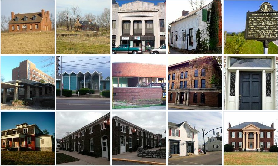
Photographs of Select Sites on the Blue Grass Trust’s Eleven in Their Eleventh Hour List

Each year, the Blue Grass Trust for Historic Preservation assembles a list of historic central Kentucky properties which are threatened. For the 2015 edition of the “Eleven in Their Eleventh Hour” list, the BGT has looked primarily beyond Fayette County to sites across 11 central Kentucky counties.

The list of counties largely resembles those included in the 2006 World Monument Fund’s designation of the Inner Bluegrass Region. The Blue Grass Trust included Madison County on its “11 Endangered List” while omitting Anderson County. All Kentucky counties, however, have “at risk” structures and deserve the attention of preservationists.

The BGT’s list is a great step toward recognizing that preservation can and should occur throughout Kentucky and not only in our urban cores. The 14 structures within the 11 counties also reflect that theme.

According to the BGT, “the list highlights endangered properties and how their situations speak to larger preservation issues in the Bluegrass. The goal of the list is to create a progressive dialogue that moves toward positive long-term solutions. The criteria used for selecting the properties include historic significance, lack of protection from demolition, condition of structure, or architectural significance.”

The sites are listed below.

Bourbon County – Cedar Grove & John T. Redmon House 

Both Cedar Grove and the Redmon House are architecturally significant houses from the early 19th century. The circa 1818 John & John T. Redmon House has a steep roof more often found in Virginia than Kentucky and has lost its original one-story wings. Though both buildings are vacant, they have undergone partial renovations recently and the BGT believes these structures could be still restored.

Boyle County – Citizens National Bank & Dr. Polk House

Mostly empty for two-plus years, the Citizens National Bank building at 305 West Main Street in Danville was built in 1865 with a double storefront that housed First National Bank of Danville and a drug store. Bank-owned and listed for sale, a demolition (or partial demolition) of this structure could affect adjacent structures with which the building shares walls.  Dr. Polk House at 331 South Buell Street in Perryville sits across from Merchants’ Row and is arguably the historic landmark most in need of restoration in the downtown. Built in 1830 as a simple Greek Revival house with two chimneys and two front doors, the structure was purchased by Dr. Polk in 1850. A graduate of Transylvania University, he was the primary caretaker of wounded from the Battle of Perryville and his 1867 autobiography details the gruesome battlefield.

Dr. Polk House in Perryville, Kentucky. Photo courtesy of the BGT.

Clark County – Indian Old Fields 

Indian Old Fields in Clark County was the location of Eskippakithiki, the last known Native American town in what became Kentucky. Located on Lewis Evans’ 1755 map of Middle British Colonies, this highly important site was significantly impacted during construction of a new interchange (which opened September 2014) for the Mountain Parkway crossing KY 974 near the center of the Indian Old Fields.

The Kentucky Heritage Council noted in 2010 that “’Indian Old Fields,’ is a historic and prehistoric archaeological district of profound importance,” with 50 significant prehistoric archaeological sites identified within 2 kilometers of the interchange. These sites cover the Archaic Period (8000-1000 BC), Woodland Period (1000 B.C. -1000 AD) and Adena Period (1000-1750 AD), with several listed on the National Register of Historic Places. These include villages, Indian fort earthworks, mounds, sacred circles and stone graves. The site also has substantial ties to the famous Shawnee Chief Cathecassa or Black Hoof, Daniel Boone, and trader John Finley.

With the new $8.5 million dollar interchange now open, there are significant concerns that these sites with be under threat from pressure to further develop the area.

Fayette County – Modern Structures 

The Blue Grass Trust’s 2014 “Eleven in Their Eleventh Hour” focused on the historic resources at the University of Kentucky. Many of those included on the list (and most of those demolished) were Modern buildings designed by locally renowned architect Ernst Johnson. Research into Johnson’s work by the BGT and others such as architects Sarah House Tate and Dr. Robert Kelley was joined with education and advocacy programming focused on his architecture and legacy as a master of Modernism. This research and programming led to other efforts by the Blue Grass Trust, namely working to educate the public on the historic value of mid-century architecture.

In our continued education and advocacy effort surrounding these structures, the Blue Grass Trust lists Fayette County’s mid-century Modern architecture as endangered. Often viewed as not old enough or not part of the traditional early fabric of Lexington and surrounding areas, the Modern buildings of the 1940s, ’50s and ’60s are being substantially and unrecognizably altered or demolished. It is important to recognize that buildings 50 years of age are eligible for listing on the National Register of Historic Places, a length of time deemed appropriate by the authors of the National Historic Preservation Act of 1966 for reflection on an era’s importance. Read more from the Kaintuckeean’s earlier post on the People’s Bank branch on South Broadway.
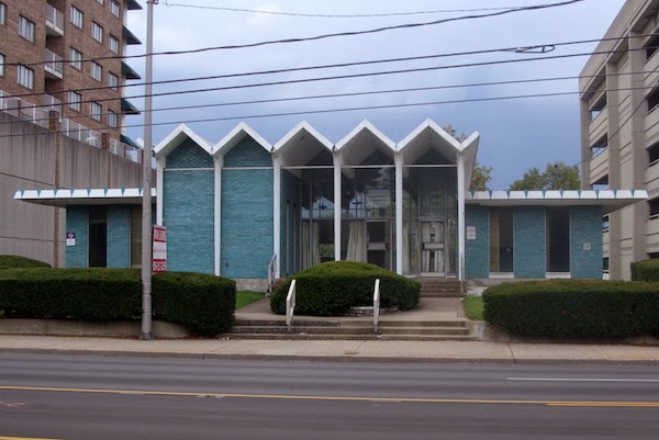
People’s Bank in Lexington. Photo by Rachel Alexander.

Franklin County – Old YMCA & Blanton-Crutcher Farm

Both the Old YMCA in downtown Frankfort faces potential demolition and the Blanton-Crutcher Farm in Jett are slowly deteriorating from neglect and both structures are worth saving. The 1911 Old YMCA at 104 Bridge Street in Frankfort, designed in the Beaux Arts style by a a Frankfort architect, was a state-of-the-art facility featuring a gymnasium, indoor swimming pool, bowling alley, meeting rooms and guest quarters. While a local developer is hoping to transform it into a boutique hotel, there is also a push by the city of Frankfort to demolish this structure. If saved, this could be a transformative project in our capital city. 

The Blanton-Crutcher Farm in Jett includes an architecturally and historically significant circa 1796 house built by Carter Blanton, a prominent member of the Jett farming community. In 1831, Blanton sold the farm to his nephew, Richard Crutcher, the son of Reverend Isaac Crutcher and Blanton’s sister, Nancy Blanton Crutcher. The 1974 National Register nomination for the farm notes: “The Crutchers were excellent farmers. Three generations of the family farmed the land and made improvements on the house until 1919 when the property was sold. It has remained a working farm with a large farmhouse, at its center, that has evolved over 180 years of active occupation.” In the 1880s, Washington Crutcher significantly increased the size of the house, turning it into the Victorian house that stands today (although the porches were removed due to deterioration and other modern features have been added).

Harrison County – The Handy House aka Ridgeway 

The Handy House, also known as Ridgeway, is located on US 62 in Cynthiana, KY. The nearly 200-year-old house was built in 1817 by Colonel William Brown, a United States Congressman and War of 1812 veteran. The farm and Federal-style house were also owned by Dr. Joel Frazer, namesake of Camp Frazer, a Union camp during the American Civil War. In the 1880s, the house underwent significant renovations by W. T. Handy, the owner from 1883-1916 and for whom the house remains named.

The Handy House checks almost every box when it comes to saving a structure: an architecturally and historically important house in good enough shape to rehabilitate, a listing on the National Register of Historic Places, qualification for the Kentucky Historic Preservation Tax Credit, and a group, the Harrison County Heritage Council and a descendant of the original owner, willing to take on the project. Unfortunately, the Handy House is jointly owned between the city and the county. County magistrates voted to tear it down, and the city opted not to vote on it with the hopes that the new council will come to a deal with the Harrison County Heritage Council, which has offered to purchase and restore the house as a community center. Read more from the Kaintuckeean’s earlier post on Ridgeway.

Jessamine County – Court Row 

Completed in 1881, Nicholasville’s Court Row is located right next to the Jessamine County Courthouse. Italianate in design and largely unchanged exterior-wise, Court Row is one of the most significant and substantial structures in downtown Nicholasville.

In a broad context, the listing of Court Row is a comment on the status of all the historic resources in downtown Nicholasville. Several threats exist that are culminating in drastic changes to the fabric of the town. Foremost, Nicholasville failed in 2013 to pass its first historic district, an overlay that would have encompassed the majority of the downtown and helped to regulate demolition and development. Then, within the past month, two historic structures were demolished, including the Lady Sterling House, an 1804 log cabin very close to the urban core. Additionally, Nicholasville is on the ‘short list’ for a new judicial center, the location of which has yet to be determined but will almost certainly have an effect on the downtown. Together, these threats present the potential for the loss of significant portions of Nicholasville’s charming downtown.

Madison County – Downtown Richmond 

Preservation has had a lot positive movement in Richmond. The Madison County Historical Society is active; the beautiful Irvinton House Museum is city-owned and the location of the Richmond Visitor’s Center; and the downtown contains a local historic district. Like most local historic districts (also known as H-1 overlays), though, the Downtown Richmond Historic District protects historic buildings and sites that are privately owned. That means that city- and county-owned sites are exempt from the H-1 regulations.

The potential damaging effects of this can already be seen. In February 2013, downtown Richmond lost the Miller House and the Old Creamery, two of its most historic buildings. Both were in the Downtown Richmond Historic District and on the National Register of Historic Places. Owned by the county, the buildings were demolished with the hopes of constructing a minimum-security prison on the site that would replicate the exterior façade of the Miller House, according to Madison Judge/Executive Kent Clark. There are several other historic sites in the urban core that are owned by either the city or the county, leading to worry about the state of preservation in Richmond’s downtown.

Mercer County – Walnut Hall

Built circa 1850 by David W. Thompson, Walnut Hall is one of Mercer County’s grand Greek Revival houses. A successful planter and native of Mercer County, Thompson left the house and 287 acres of farmland to his daughter, Sue Helm, upon his death in 1865. In 1978, Walnut Hall was listed on the National Register of Historic Places along with two other important and similar Mercer County Greek Revival houses: Lynnwood (off KY Highway 33 near the border of Mercer and Boyle Counties) and Glenworth (off Buster Pike).

The James Harrod Trust has notified the Blue Grass Trust that the house may be under threat of demolition, as it is owned by a prominent Central Kentucky developer known to have bulldozed several other important historic buildings.

Scott County – Choctaw Indian Academy 

Located in Blue Springs, KY, off Route 227 near Stamping Ground, the Choctaw Indian Academy was created in 1818 on the farm of Colonel Richard M. Johnson, who served as Vice President of the United States under Martin Van Buren (1837–1841). The Academy was created using Federal funding and was intended to provide a traditional European-American education for Native Americans boys. (It was one of only two government schools operated by the Department of War – the other being West Point.) Originally consisting of five structures built prior to 1825, only one building – thought to be a dormitory – remains. By 1826, over 100 boys were attending the school, becoming well enough known to be visited by the Marquis de Lafayette in 1825. The school was relocated to White Sulphur Springs (also a farm owned by Colonel Johnson) in 1831. The site was listed on the National Register of Historic Places in 1972. Read more about the site from the Kaintuckeean’s earlier post on the Choctaw Indian Academy.

Remaining structure of Choctaw Indian Academy. Photo by Amy Palmer.


Woodford County – Versailles High School 

 Located on the corner of Maple Street and Lexington Pike in Versailles, the Versailles High School is a substantial structure built in 1928. The building operated as a high school for 35 years before becoming the Woodford County Junior High in 1963, operating as a middle school until being shuttered in 2005. After 77 years of continuous operation, the building has been empty for nearly 10 years.

With no known maintenance or preservation plan, concern exists that the historic Versailles High School will deteriorate from neglect and, ultimately, be demolished.

You can learn more about the Blue Grass Trust for Historic Preservation on its website, www.bluegrasstrust.org.

A Snow Covered Nicholasville

The Jessamine County Courthouse in Nicholasville, Ky.

In the height of last week’s snow, I set out on a walk from my house through downtown Nicholasville. I was well bundled, stayed quite warm, and had fun seeing this town covered in a thick layer of beautiful white snow. I saw a few others out and about, but it was by and large a quiet affair.

By my measurements at home, we received a full 12″ of snow in Nicholasville. An additional 2.75″ had fallen on the ground by Tuesday morning. Although the students in Lexington are headed back to class today, Jessamine County schools will be closed for the 6th consecutive school day.

In a twist of irony, Nicholasville Elementary’s winter production is entitled “The Big Chill.” 
No kidding.

Outdoor dining at Nicholasville’s Euro on Main Street.

Walker Hotel
The old Walker Hotel at Main and Chestnut streets.

Two friendly faces I saw on my walk – Danny and Libby Barnes had an “open” sign at their 
Alternative Jewelry Store on Main Street in Nicholasville.
If you enjoyed these photographs, be sure to check out the other images of a snow covered Nicholasville as posted on flickr

Discovering The Trails of Jessamine County

Kentucky River winding through the Bluegrass. Author’s Collection.

Of the Bluegrass region, J. Soule Smith wrote in his “Bluegrass Region of Kentucky in 1898”:

The best part of it winds the Kentucky River, which has cut its deep bed into the soft rocks there hundred feet below the surface, and presents its picturesque cliffs in many featured crags as sentinels over the wimpling waves below … It is near to Heaven and most blest of all the earth.

If you’ve spent time in the Palisades, either kayaking the waters of the Kentucky River or hiking above or below the cliffs, you have personally witnessed the blessed place we live in. Or perhaps you’ve seen the sun rise or set over the rolling Bluegrass hills on a Jessamine County farm with centuries-old trees dotting the landscapes.

Yes, we are fortunate to live in such a beautiful place. But, too often, many of us are confined to our daily urban and suburban patterns. Getting out into nature is a treat, one made easier with publicly accessible trails.

Trails come in a wide variety. Some require great energy and involve steep grades, while others are paved and easily accessible by those of all abilities.

Some of the region’s best-known public trails include those at Lexington’s 734-acre Raven Run. Across the Kentucky River from Jessamine County are a series of nature preserves along the Palisades and separating the counties is the Kentucky River Blueway Trail along Jessamine County’s 42-mile waterfront.

Trails for all abilities at Garrard County’s Dupree Nature Preserve. Author’s Collection.

There are also a number of trails within Jessamine County. The US-68 mixed-use trail provides jogging and bicycling opportunity, as does the much shorter Riney B. Park trail. The longest mountain bike trail in the county is currently accessible only via Lexington’s Veterans Park. Other trail opportunities exist at Wilmore’s Centennial Park and at Camp Nelson, and there are more trails in Jessamine County. But many of these are unknown to the general public.

Despite the health and economic benefits of trails, local officials have kept secret many of these treasures. Hikes were possible, by appointment only. But restrictions have softened on access to public lands in our county. Now a consortium of parks and recreation, the YMCA, the health department, St. Joseph Jessamine, the Chamber of Commerce, and the Jessamine County Trails Association is in the process of identifying all of the trails in Jessamine County.

The consortium’s goal is to produce a brochure and map highlighting these Jessamine County resources. If you’re interested in helping to evaluate, photograph and help discover Jessamine County’s trails, contact Lindsay Ames at the health department, 885-2310, or John Howard at parks and recreation, 885-9787. You can also learn more on the Facebook page for the Jessamine County Trails Association.

Lindsay Ames, the Jessamine County Health Department’s Health Environmentalist, regularly hikes the trails of the Bluegrass. “When you simply need a quick escape into nature, the [Jim Beam Trail off Payne Lane] is conveniently located just minutes from Nicholasville,” says Ames.

According to Ames, the shorter Jim Beam Trail has a variety of sights close to home: “you are in the woods above the river, the elevation changes for some hill climbs, and you get some pretty cool views of the Palisades. While popular destinations like Red River Gorge are known for hiking trails, the local hiker may be pleasantly surprised to discover that there are actually a few adventurous trails within just a short drive.”

With random warm weekends popping up during Kentucky winters, it is ideal to plan for a spontaneous hiking excursion. With the leaves off the trees, views and landscapes are particularly spectacular. Year round, you can get out and discover that you live in a place that is “most blest of all the earth.”

The post above was originally published in the Jessamine Journal on January 8, 2015.